IMAGES TAKEN NEAR TO
High Street, ST. ALBANS, AL3 4EL
Introduction
This page details the photographs taken nearby to High Street, AL3 4EL by members of the Geograph project.
The Geograph project started in 2005 with the aim of publishing, organising and preserving representative images for every square kilometre of Great Britain, Ireland and the Isle of Man.

There are currently over 7.5m images from over14,400 individuals and you can help contribute to the project by visiting https://www.geograph.org.uk
Image Map
Images are licensed for reuse under creativecommons.org/licenses/by-sa/2.0
Notes
- Clicking on the map will re-center to the selected point.
- The higher the marker number, the further away the image location is from the centre of the postcode.
Image Listing (859 Images Found)
Images are licensed for reuse under creativecommons.org/licenses/by-sa/2.0
Image
Details
Distance
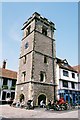
1
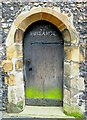
Door in Clock Tower
An unobtrusive door that attracts unwanted attention
Image: © John Reeves
Taken: 27 Feb 2013
0.00 miles
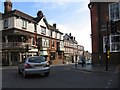
2
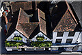
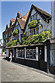
The Boot
Looking down on the Boot from the Clock Tower.
The building dates originally from around 1500 (although the pub's own website claims a date of 1420). It originally consisted of two timber framed buildings, one containing two shops fronting Market Place, the other set lengthways behind the pair (seen in the background to the photo). Various modifications and extensions took place over the years - for example the cross-element of the roof was added in the 18th century, to house three attic rooms.
It is first recorded as a licensed establishment in 1719, occupying the section under the left hand gable - the extension to include the second section did not take place until the 1960s.
The name is presumed to originate from this section of the market being for leather traders - in fact leather offcuts discovered under floorboards suggest that part of the building may have contained workshops for that trade.
For full history see http://www.salbani.co.uk/Pubs/bootweb/the_boot.htm.
Grade II listed - see www.historicengland.org.uk/listing/the-list/list-entry/1347171.
The building to its right, 2 Market Place, dates from the 17th century and is also grade II listed - see www.historicengland.org.uk/listing/the-list/list-entry/1103071.
Image: © Ian Capper
Taken: 20 Apr 2013
0.00 miles
4
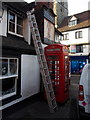
St. Albans: phone box behind the Boot pub
This traditional red phone box stands just off the market place, beneath a pub sign for the Boot. In the background can be seen part of Image
Image: © Chris Downer
Taken: 6 Jan 2014
0.00 miles
9
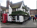
The Boot
The building dates originally from around 1500 (although the pub's own website claims a date of 1420). It originally consisted of two timber framed buildings, one containing two shops fronting Market Place, the other set lengthways behind the pair. Various modifications and extensions took place over the years.
It is first recorded as a licensed establishment in 1719, occupying the section under the left hand gable - the extension to include the second section did not take place until the 1960s.
The name is presumed to originate from this section of the market being for leather traders - in fact leather offcuts discovered under floorboards suggest that part of the building may have contained workshops for that trade.
For full history see http://www.salbani.co.uk/Pubs/bootweb/the_boot.htm.
Grade II listed - see www.historicengland.org.uk/listing/the-list/list-entry/1347171.
Image: © Ian Capper
Taken: 20 Apr 2013
0.01 miles
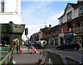
10
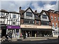
The Dressing Room
6-8 High Street, St Albans
Image: © Andrew Abbott
Taken: 13 Apr 2019
0.01 miles