IMAGES TAKEN NEAR TO
Camp Road, ST. ALBANS, AL1 5EH
Introduction
This page details the photographs taken nearby to Camp Road, AL1 5EH by members of the Geograph project.
The Geograph project started in 2005 with the aim of publishing, organising and preserving representative images for every square kilometre of Great Britain, Ireland and the Isle of Man.

There are currently over 7.5m images from over14,400 individuals and you can help contribute to the project by visiting https://www.geograph.org.uk
Image Map
Images are licensed for reuse under creativecommons.org/licenses/by-sa/2.0
Notes
- Clicking on the map will re-center to the selected point.
- The higher the marker number, the further away the image location is from the centre of the postcode.
Image Listing (102 Images Found)
Images are licensed for reuse under creativecommons.org/licenses/by-sa/2.0
Image
Details
Distance
1
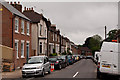
Albion Road
Road largely developed in the 1880s on the site of a former nursery, Ninedells.
Image: © Ian Capper
Taken: 26 Jun 2012
0.08 miles
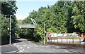
2

The Old Salvation Army Halt Station, St Albans
Located on the 'Alban Way' cycle and footpath are the remains of the passenger platform of the long disused 'Salvation Army Halt' station. Photographed looking Southwest. The name came from the Salvation Army printing works on Campfield Road. The station was part of the St Albans to Hatfield Railway which closed to passengers in 1951 and freight in 1964. It was also known as 'Sander's Siding' after Sander's Orchids on Camp Road and whose siding was behind the photographer.
Image: © Barry Lawson
Taken: 24 Jan 2006
0.08 miles
3
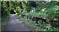
Salvation Army Halt
Along the old railway line between St Albans and Hatfield which is now a cycle route, the Alban Way.
For a short line it had a lot of stations. Some are looked after by local enthusiasts, but not this one, although a name board has been put up. Otherwise it is just as overgrown as it was 19 years ago. Image
It has been closed since 1951, so it's surprising that even this much remains.
Image: © Des Blenkinsopp
Taken: 25 Aug 2024
0.09 miles
5
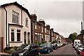
Albion Road
Road largely developed in the 1880s on the site of a former nursery, Ninedells.
Image: © Ian Capper
Taken: 26 Jun 2012
0.10 miles
7
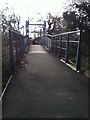
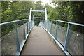
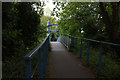
Alban Way Bridge over Camp Road
Carries the Alban Way - a cycle and footpath along the former Great Northern Railway branch line from Hatfield to St Albans. This bridge was erected in 2003 and allows people to cross Camp Road without having to come down from the embankment top, cross the road and climb up again.
I've added this photo, taken by the pedestrian crossing visible in Image as there a number of pictures of the top of the bridge but none from this angle! (See Image, Image and others.)
Image: © John Webb
Taken: 14 Oct 2023
0.10 miles
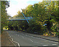
8
Alban Way Bridge, Camp Road
The Alban Way is a cycleway between St Albans and Hatfield along an old railway line. The bridge here is a narrower, lighter structure replacing what must have been quite a low old railway bridge.
Image: © Des Blenkinsopp
Taken: 25 Aug 2024
0.10 miles
10
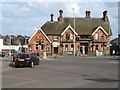
St Albans: The Crown
Formerly The Crown Hotel the pub occupies a prominent location on Hatfield Road. It probably dates from the 1890s.
The 1901 Census return gives the following occupiers:
Mary Clarke, a licenced victualler, aged 54, a widow with her children Emily, Margery, William and Bernard, aged 28, 20, 17 and 13.
In the 1911 Census it's the identical family, described as Mary Clarke, a licenced victualler, aged 65, a widow with her children Emily, Margery, William and Bernard, aged 38, 30, 27 and 24. By this time William was the manager of the public house while the other three were assisting in the business, all of the four children being single.
Image: © Nigel Cox
Taken: 24 Jun 2010
0.10 miles