IMAGES TAKEN NEAR TO
Beechwood Avenue, ST. ALBANS, AL1 4YA
Introduction
This page details the photographs taken nearby to Beechwood Avenue, AL1 4YA by members of the Geograph project.
The Geograph project started in 2005 with the aim of publishing, organising and preserving representative images for every square kilometre of Great Britain, Ireland and the Isle of Man.

There are currently over 7.5m images from over14,400 individuals and you can help contribute to the project by visiting https://www.geograph.org.uk
Image Map (Loading...)


Getting Data...Please wait
Leaflet Map data © OpenStreetMap
Images are licensed for reuse under creativecommons.org/licenses/by-sa/2.0
Notes
- Clicking on the map will re-center to the selected point.
- The higher the marker number, the further away the image location is from the centre of the postcode.
Image Listing (10 Images Found)
Images are licensed for reuse under creativecommons.org/licenses/by-sa/2.0
Image
Details
Distance
1
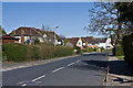
Beaumont Avenue
Late 1920s/1930s housing with some later infilling..
Image: © Ian Capper
Taken: 20 Apr 2013
0.13 miles
2
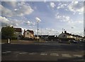
Roundabout on Beechwood Avenue, St Albans
At the junction of Hatfield Road
Image: © David Howard
Taken: 28 May 2015
0.14 miles
3
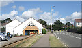
Ashley Church
An independent Christian church simply named after the road it's in.
More about it on https://www.findachurch.co.uk/church/st-albans/24777.htm
Image: © Des Blenkinsopp
Taken: 25 Aug 2024
0.19 miles
4
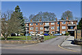
Queens Court
1950s apartments on Hatfield Road.
Image: © Ian Capper
Taken: 20 Apr 2013
0.19 miles
5
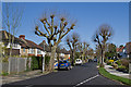
Salisbury Avenue
Late 1920s/1930s housing.
Image: © Ian Capper
Taken: 20 Apr 2013
0.19 miles
6
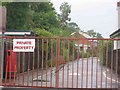
Entrance gates to Beaumont School, Oakwood Drive
The bent bars on the gate show they have poor drivers. Not sure of the status of the school
Image: © Jack Hill
Taken: 19 Aug 2005
0.20 miles
7
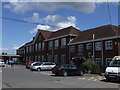
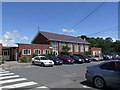
Beaumont School, St.Albans
First opened in 1938 and celebrating it's 70th Birthday in 2008.
The school was built on the site of Beaumonts Farm.
Never any cars there in my day.
Image: © Dave Skinner
Taken: 5 Jul 2008
0.23 miles
8
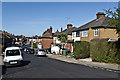
Salisbury Avenue
A stub of Salisbury Avenue where it merges into Eaton Road. Eaton Road consists of late Victorian, early 20th century terraced housing - the exception is nos 17/19, the building on the right of the road in the centre of the photo, with the tall chimney, which was destroyed in an air raid in the Autumn of 1940 and was later rebuilt. Old maps show a sharp edge to development that point, with the semi detached and detached houses of Salisbury Avenue being built in the late 1920s or 1930s.
Image: © Ian Capper
Taken: 20 Apr 2013
0.23 miles
9
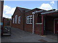
Beaumont School, St.Albans, Science Block
Entrance to the Science Block. In my day the taller building in the middle was the Sixth Form Common and Dining Room. I seem to recall that before that someone told me it had been the Gym. The two lower blocks on each end were the girls (left) and boys (right) cloakrooms.
Image: © Dave Skinner
Taken: 5 Jul 2008
0.24 miles
10
Beaumont School
The old woodwork rooms, leading up to the Bike Sheds !
The main hall is just on the left and the boy's toilet entrance can be seen on the right.
Image: © Dave Skinner
Taken: 5 Jul 2008
0.25 miles