IMAGES TAKEN NEAR TO
Clarence Road, ST. ALBANS, AL1 4NG
Introduction
This page details the photographs taken nearby to Clarence Road, AL1 4NG by members of the Geograph project.
The Geograph project started in 2005 with the aim of publishing, organising and preserving representative images for every square kilometre of Great Britain, Ireland and the Isle of Man.

There are currently over 7.5m images from over14,400 individuals and you can help contribute to the project by visiting https://www.geograph.org.uk
Image Map
Images are licensed for reuse under creativecommons.org/licenses/by-sa/2.0
Notes
- Clicking on the map will re-center to the selected point.
- The higher the marker number, the further away the image location is from the centre of the postcode.
Image Listing (82 Images Found)
Images are licensed for reuse under creativecommons.org/licenses/by-sa/2.0
Image
Details
Distance
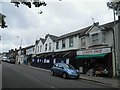
3

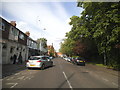
Looking west along Hatfield Road (A1057)
The silver-painted car is parked near to the entrance to St Paul’s Place.
Image: © John Baker
Taken: 10 Jun 2015
0.07 miles
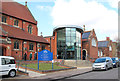
4
St. Paul's Church, Hatfield Road, St. Albans
Image: © Dr Neil Clifton
Taken: 16 Jan 2008
0.07 miles
5
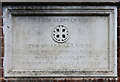
St Paul, Blandford Road, St Albans - Foundation stone
Image: © John Salmon
Taken: 14 Mar 2013
0.07 miles
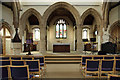
6
St Paul, Blandford Road, St Albans - Organ
Image: © John Salmon
Taken: 14 Mar 2013
0.07 miles
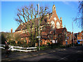
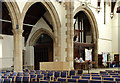
8
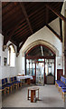
St Paul, Blandford Road, St Albans - East end
Image: © John Salmon
Taken: 14 Mar 2013
0.08 miles
9
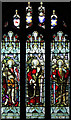
St Paul, Blandford Road, St Albans - Stained glass window
Image: © John Salmon
Taken: 14 Mar 2013
0.08 miles
10
St Paul, Blandford Road, St Albans - Chapel
Image: © John Salmon
Taken: 14 Mar 2013
0.08 miles