IMAGES TAKEN NEAR TO
Sandpit Lane, ST. ALBANS, AL1 4DY
Introduction
This page details the photographs taken nearby to Sandpit Lane, AL1 4DY by members of the Geograph project.
The Geograph project started in 2005 with the aim of publishing, organising and preserving representative images for every square kilometre of Great Britain, Ireland and the Isle of Man.

There are currently over 7.5m images from over14,400 individuals and you can help contribute to the project by visiting https://www.geograph.org.uk
Image Map
Images are licensed for reuse under creativecommons.org/licenses/by-sa/2.0
Notes
- Clicking on the map will re-center to the selected point.
- The higher the marker number, the further away the image location is from the centre of the postcode.
Image Listing (162 Images Found)
Images are licensed for reuse under creativecommons.org/licenses/by-sa/2.0
Image
Details
Distance
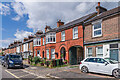
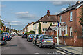
1
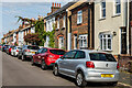
Culver Road
Housing in the mainly late 19th/early 20th Century development of "Sandridge New Town", an area of land between Sandpit Lane and Sandridge Road, originally outside the boundaries of St Albans and in the parish of Sandridge, prior to the extension of the municipal area in 1879, just south of where Boundary Road was laid out.
Image: © Ian Capper
Taken: 11 Sep 2020
0.02 miles
2
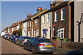
Culver Road
Late Victorian terraced cottages. Prior to the development of this area it was outside the St Albans boundary, and was instead part of Sandridge. The area was absorbed into St Albans when the city boundaries were extended in 1879, but when developed was still known as Sandridge New Town. All the cottages are locally listed.
Image: © Ian Capper
Taken: 2 Oct 2011
0.02 miles
3
Culver Road
Housing in the mainly late 19th/early 20th Century development of "Sandridge New Town", an area of land between Sandpit Lane and Sandridge Road, originally outside the boundaries of St Albans and in the parish of Sandridge, prior to the extension of the municipal area in 1879, just south of where Boundary Road was laid out. The nearest building has a plaque inscribed "St Lukes 1898".
Image: © Ian Capper
Taken: 11 Sep 2020
0.02 miles
4
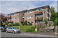
Heathfield Court
Block of 12 flats built in the late 20th Century replacing an Edwardian house, 21 Avenue Road.
Image: © Ian Capper
Taken: 19 Aug 2021
0.04 miles
5
Culver Road
Housing in the mainly late 19th/early 20th Century development of "Sandridge New Town", an area of land between Sandpit Lane and Sandridge Road, originally outside the boundaries of St Albans and in the parish of Sandridge, prior to the extension of the municipal area in 1879, just south of where Boundary Road was laid out.
Although most of this section of the road was built in the late 19th Century, being shown on the 1898 1:2,500 map, the building in the centre of this photo including the archway, is later, with the plot shown as undeveloped on that map. However development, both on the road and behind, is shown on the 1924 edition, with the 1963 1:1,250 map marking it as a builder's yard. The buildings behind were converted to housing in the early 2000, as The Mews.
Image: © Ian Capper
Taken: 5 Jul 2021
0.04 miles
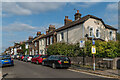
6
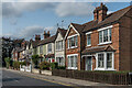
1 - 11 Sandpit Lane
Terrace of villas at the start of Sandpit Lane, dating from around the turn of the 19th/20th Centuries. The nearest two have name plaques in the gables of Park Villa (no 11) and Enmore (no 9).
Image: © Ian Capper
Taken: 11 Sep 2020
0.04 miles
7
Culver Road
Housing in the mainly late 19th/early 20th Century development of "Sandridge New Town", an area of land between Sandpit Lane and Sandridge Road, originally outside the boundaries of St Albans and in the parish of Sandridge, prior to the extension of the municipal area in 1879, just south of where Boundary Road was laid out.
The plaque on the nearest building is inscribed "Gladstone Cottage".
Image: © Ian Capper
Taken: 5 Jul 2021
0.04 miles
8
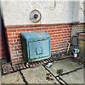
Domestic gas supply, Heath Road, St Albans
Image: © Robin Stott
Taken: 7 Mar 2023
0.05 miles
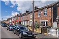
9
Heath Road
Housing in the mainly late 19th/early 20th Century development of "Sandridge New Town", an area of land between Sandpit Lane and Sandridge Road, originally outside the boundaries of St Albans and in the parish of Sandridge, prior to the extension of the municipal area in 1879, just south of where Boundary Road (in the background) was laid out. Most of the housing in the area is terraced - the two nearest buildings at the southern end of Heath Road are an exception.
Image: © Ian Capper
Taken: 11 Sep 2020
0.05 miles
10
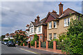
17 & 19 Avenue Road
A pair of Edwardian houses in Avenue Road. Slightly hidden beyond, with the dormer window, is no 15, one of the few houses on the road shown on the 1898 25 inch map.
Image: © Ian Capper
Taken: 19 Aug 2021
0.05 miles