IMAGES TAKEN NEAR TO
Sandpit Lane, ST. ALBANS, AL1 4DF
Introduction
This page details the photographs taken nearby to Sandpit Lane, AL1 4DF by members of the Geograph project.
The Geograph project started in 2005 with the aim of publishing, organising and preserving representative images for every square kilometre of Great Britain, Ireland and the Isle of Man.

There are currently over 7.5m images from over14,400 individuals and you can help contribute to the project by visiting https://www.geograph.org.uk
Image Map
Images are licensed for reuse under creativecommons.org/licenses/by-sa/2.0
Notes
- Clicking on the map will re-center to the selected point.
- The higher the marker number, the further away the image location is from the centre of the postcode.
Image Listing (147 Images Found)
Images are licensed for reuse under creativecommons.org/licenses/by-sa/2.0
Image
Details
Distance
1
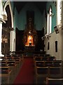
St Saviour, Sandpit Lane, St Albans: crossing
Image: © Chris Brown
Taken: 19 Feb 2018
0.00 miles
2
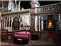
St Saviour, Sandpit Lane, St Albans: screens
The Gothic chancel rood screen by Frank Peck and the chapel screen dating from the 1920s, by Martin Travers.
Image: © Chris Brown
Taken: 19 Feb 2018
0.01 miles
3
St Saviour, Sandpit Lane, St Albans: interior
Image: © Chris Brown
Taken: 19 Feb 2018
0.01 miles
4
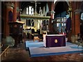
St Saviour, Sandpit Lane, St Albans: chancel
Image: © Chris Brown
Taken: 19 Feb 2018
0.01 miles
5
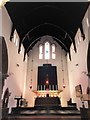
St Saviour, Sandpit Lane, St Albans: south chapel
Like the chapel's screens, the Baroque reredos of 1925 was designed by Martin Travers.
Image: © Chris Brown
Taken: 19 Feb 2018
0.01 miles
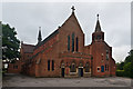
6
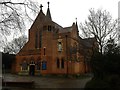
St Saviour, Sandpit Lane, St Albans
Built to designs of William Woodward of London, 1902.
Image: © Chris Brown
Taken: 19 Feb 2018
0.02 miles
7

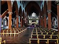
St Saviour, Sandpit Lane, St Albans: nave looking west
Image: © Chris Brown
Taken: 19 Feb 2018
0.02 miles
8
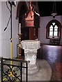
St Saviour, Sandpit Lane, St Albans: font
The font of this church built in 1902 is 15th century and was brought from Maldon in Essex.
Image: © Chris Brown
Taken: 19 Feb 2018
0.02 miles
9
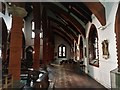
St Saviour, Sandpit Lane, St Albans: north aisle
North in the liturgical sense: the church is aligned north to south and so this "north" aisle is actually the west side of the church nave.
Image: © Chris Brown
Taken: 19 Feb 2018
0.02 miles
10
St Saviour's Church
Completed in 1902 on land gifted by Earl Spencer, who owned much of the area. It replaced an iron mission church in nearby Culver Road, serving the late Victorian development known as Sandridge New Town.
It was designed by London architect William Woodward and built of bricks fired at a local brickworks (now long gone) on nearby Heath Farm, which happened to be run by the Churchwarden, Jacob Reynolds.
Grade II listed - see www.historicengland.org.uk/listing/the-list/list-entry/1392600.
Image: © Ian Capper
Taken: 26 Jun 2012
0.02 miles