IMAGES TAKEN NEAR TO
Beaconsfield Road, ST. ALBANS, AL1 3RG
Introduction
This page details the photographs taken nearby to Beaconsfield Road, AL1 3RG by members of the Geograph project.
The Geograph project started in 2005 with the aim of publishing, organising and preserving representative images for every square kilometre of Great Britain, Ireland and the Isle of Man.

There are currently over 7.5m images from over14,400 individuals and you can help contribute to the project by visiting https://www.geograph.org.uk
Image Map
Images are licensed for reuse under creativecommons.org/licenses/by-sa/2.0
Notes
- Clicking on the map will re-center to the selected point.
- The higher the marker number, the further away the image location is from the centre of the postcode.
Image Listing (234 Images Found)
Images are licensed for reuse under creativecommons.org/licenses/by-sa/2.0
Image
Details
Distance
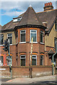
2
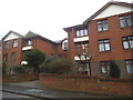
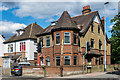
Beaconsfield Road
Turn of the 19th/20th Century housing in Beaconsfield Road. In the right background is the tower of SS Stephen and Alban Catholic Church.
Image: © Ian Capper
Taken: 11 Jul 2020
0.02 miles
3
Stink pipe, St Albans
This truncated cast-iron pipe stands for a while longer at the corner of Hatfield Road A1057 and Lemsford Road. It is marked
HAM BAKER & CO
LIMITED
ENGINEERS
WESTMINSTER
Photo number 7614070.
Image: © Robin Stott
Taken: 3 Aug 2023
0.05 miles
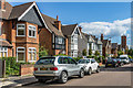
4
Entrance to Loreto College on Hatfield Road
The gate to the girl's school, the other entrances are in Upper Lattimore Road and Beaconsfield Road.
Image: © David Howard
Taken: 28 May 2015
0.06 miles
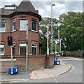
5
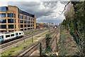
Northern approach to St Albans City station
The ThamesLink train on the left is in a siding (services regularly terminate at St Albans City) awaiting the call from points south of the Thames.
Image: © Robin Stott
Taken: 6 Apr 2023
0.06 miles
6
Channel cover, St Albans
Of cast iron, at the south end of Lemsford Road, it bears the name: DUMPLETON BUILDER ST ALBANS.
Image reference: 7456036
Image: © Robin Stott
Taken: 6 Apr 2023
0.06 miles
7
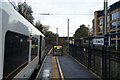
Platform 3, St Albans City Railway Station
The bridge in the distance carries the A1057 Hatfield Road.
Image: © Mark Anderson
Taken: 21 Dec 2022
0.06 miles
8
2 and 4 Lemsford Road
Early 20th Century houses on Lemsford Road, by its junction with Hatfield Road. On the pavement in front of no 2 is the base of a former sewer vent column (or "stinkpipe").
Image: © Ian Capper
Taken: 11 Jul 2020
0.06 miles
9
Sewer vent column
The base of a former sewer vent column (or "stinkpipe") in front of 2 Lemsford Road, at the junction of Lemsford Road and Hatfield Road. For wider view see Image
Image: © Ian Capper
Taken: 11 Jul 2020
0.06 miles
10
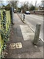
Cable marker, Hatfield Road, St Albans
This warning of an electric cable is in the footway on the east side of the Hatfield Road railway bridge. The view is west.
Image: © Robin Stott
Taken: 6 Apr 2023
0.07 miles