IMAGES TAKEN NEAR TO
Avenue Road, ST. ALBANS, AL1 3QQ
Introduction
This page details the photographs taken nearby to Avenue Road, AL1 3QQ by members of the Geograph project.
The Geograph project started in 2005 with the aim of publishing, organising and preserving representative images for every square kilometre of Great Britain, Ireland and the Isle of Man.

There are currently over 7.5m images from over14,400 individuals and you can help contribute to the project by visiting https://www.geograph.org.uk
Image Map
Images are licensed for reuse under creativecommons.org/licenses/by-sa/2.0
Notes
- Clicking on the map will re-center to the selected point.
- The higher the marker number, the further away the image location is from the centre of the postcode.
Image Listing (216 Images Found)
Images are licensed for reuse under creativecommons.org/licenses/by-sa/2.0
Image
Details
Distance
1
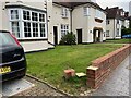
Attrition, Avenue Road, St Albans
Such damage could be called friction. It occurs everywhere between vehicles and the urban fabric; gate pillars are especially susceptible – but cars are not to be confined, are they?
Image: © Robin Stott
Taken: 17 Aug 2023
0.02 miles
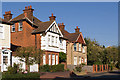
2
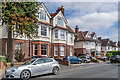
Avenue Road
Mainly Edwardian houses in Avenue Road.
Image: © Ian Capper
Taken: 19 Aug 2021
0.02 miles
3
Avenue Road
A former house (no 11) in Avenue road, now converted into flats. Both the original part and the building beyond (no 9) are locally listed.
Image: © Ian Capper
Taken: 2 Oct 2011
0.02 miles
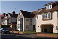
4
11 Avenue Road
Development of 15 flats built in the 1990s combining the former nos 11 and 13 Avenue Road, a pair of Edwardian houses which were retained as the two outside wings of the block.
Image: © Ian Capper
Taken: 19 Aug 2021
0.03 miles
5
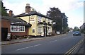
St Albans: The Jolly Sailor public house
A Charles Wells hostelry, on Stonecross as it changes into Sandridge Road, with its own very good website here
http://www.thejollysailorpub.co.uk/index.htm
Just what a Jolly Sailor had to do with St Albans was a mystery until I read the website...!
Image: © Nigel Cox
Taken: 17 Oct 2007
0.03 miles
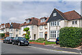
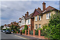
6
Avenue Road
Early 20th century houses in a road forming part of what was described at the time as "St Peter's Park". Many of the original houses, including these (nos 18 and 19) are locally listed.
Image: © Ian Capper
Taken: 2 Oct 2011
0.04 miles
7
17 & 19 Avenue Road
A pair of Edwardian houses in Avenue Road. Slightly hidden beyond, with the dormer window, is no 15, one of the few houses on the road shown on the 1898 25 inch map.
Image: © Ian Capper
Taken: 19 Aug 2021
0.05 miles
8
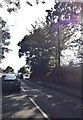
Sandridge Road, Bernards Heath
At the junction with Beech Road
Image: © David Howard
Taken: 22 Jul 2014
0.05 miles
9
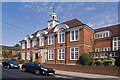
St Albans High School for Girls
An independent girls school in Townsend Avenue, founded in 1889. The main building dates from 1908 according to carvings on the door surround (see Image). It was designed by Amian Champneys, son of the Victorian architect Basil Champneys. It occupies part of the former grounds of Hall Place, a mid 15th century house demolished in 1907, which reputedly was where Henry VI was held following the First Battle of St Albans in 1455.
Although now single sex, in the past it also took boys up to the age of 10, with its most famous former pupil being Professor Stephen Hawking.
Image: © Ian Capper
Taken: 16 Sep 2011
0.06 miles
10
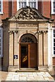
St Albans High School for Girls - main entrance
See Image This is the entrance to the main building, showing a building date of 1908.
Image: © Ian Capper
Taken: 16 Sep 2011
0.06 miles