IMAGES TAKEN NEAR TO
Lemsford Road, ST. ALBANS, AL1 3PR
Introduction
This page details the photographs taken nearby to Lemsford Road, AL1 3PR by members of the Geograph project.
The Geograph project started in 2005 with the aim of publishing, organising and preserving representative images for every square kilometre of Great Britain, Ireland and the Isle of Man.

There are currently over 7.5m images from over14,400 individuals and you can help contribute to the project by visiting https://www.geograph.org.uk
Image Map
Images are licensed for reuse under creativecommons.org/licenses/by-sa/2.0
Notes
- Clicking on the map will re-center to the selected point.
- The higher the marker number, the further away the image location is from the centre of the postcode.
Image Listing (152 Images Found)
Images are licensed for reuse under creativecommons.org/licenses/by-sa/2.0
Image
Details
Distance
1
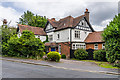
50 Lemsford Road
Turn of the 19th/20th Centuries house on Lemsford Road.
Image: © Ian Capper
Taken: 25 Jul 2020
0.00 miles
2
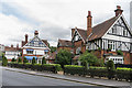
Ardmore House Hotel
Hotel on Lemsford Road, developed out of two turn of the 19th/20th Centuries houses.
Image: © Ian Capper
Taken: 25 Jul 2020
0.02 miles

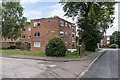
5
Thirlstane
1960s development of 7 blocks of flats off Lemsford Road.
Image: © Ian Capper
Taken: 5 Jul 2021
0.06 miles
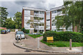
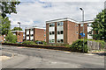
6
Summerhill Court
c1970s apartment block on Avenue Road, by its junction with Lemsford Road.
Image: © Ian Capper
Taken: 24 Jul 2020
0.08 miles
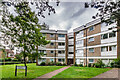
7
Eastbury Court
c1960s flats in Lemsford Road, built on the plots of two large early 20th Century houses.
Image: © Ian Capper
Taken: 24 Jul 2020
0.08 miles
8
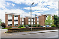
Eastbury Court
c1960s flats in Lemsford Road, built on the plots of two large early 20th Century houses.
Image: © Ian Capper
Taken: 24 Jul 2020
0.08 miles
9
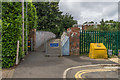
Jennings Road footbridge
Footbridge at the end of Jennings Road connecting it with Lemsford Road - this was marked on the 1898 1:2,500 map, before the road was laid out, carrying a pre-existing footpath over the railway.
Image: © Ian Capper
Taken: 25 Jul 2020
0.08 miles
10
Thirlstane
1960s development of 7 blocks of flats off Lemsford Road.
Image: © Ian Capper
Taken: 5 Jul 2021
0.09 miles