IMAGES TAKEN NEAR TO
St. Peters Street, ST. ALBANS, AL1 3LF
Introduction
This page details the photographs taken nearby to St. Peters Street, AL1 3LF by members of the Geograph project.
The Geograph project started in 2005 with the aim of publishing, organising and preserving representative images for every square kilometre of Great Britain, Ireland and the Isle of Man.

There are currently over 7.5m images from over14,400 individuals and you can help contribute to the project by visiting https://www.geograph.org.uk
Image Map
Images are licensed for reuse under creativecommons.org/licenses/by-sa/2.0
Notes
- Clicking on the map will re-center to the selected point.
- The higher the marker number, the further away the image location is from the centre of the postcode.
Image Listing (835 Images Found)
Images are licensed for reuse under creativecommons.org/licenses/by-sa/2.0
Image
Details
Distance
1
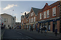
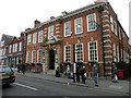
Victoria Street
The upper end of Victoria Street, looking towards its junction with Chequer Street/St Peter’s Street, with the Town Hall beyond.
Victoria Street follows the line of a much older route, a narrow lane called Shropshereslane (later Shropshire Lane), first mentioned in 1381. At its junction with St Peter’s Street stood the Castle Inn, in the entrance to which the Duke of Somerset was killed in the First Battle of St Albans in 1455.
By the 1830s the lane had been renamed Sweet Briar Lane, but remained largely undeveloped. Development did not take place until the 19th century and it was renamed Victoria Street in 1876 (initially Victoria Road at the eastern end), by which time it had become the access route from the new Midland Railway station, opened in 1868, which gave the town direct rail access to London.
The Town Hall was built in 1831 and is grade II* listed – see www.historicengland.org.uk/listing/the-list/list-entry/1296135. The buildings on the right date from the early 20th century and are all locally listed. No.1 (on the corner in the background) has an unusual turret. It used housed a branch of the National Provincial Bank (which on merger with the Westminster Bank in 1970 became part of the National Westminster Bank). The building now houses a branch of the Skipton Building Society. No.9, housing an estate agent’s, has an interesting gable.
Image: © Ian Capper
Taken: 3 Dec 2011
0.01 miles
2
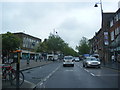
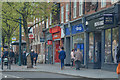
A1081 Saint Peter's Street, St.Albans
Near the junction with Victoria Street & Town Hall
Image: © Geographer
Taken: 3 Jul 2012
0.01 miles
3
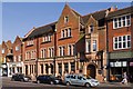
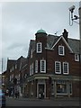
NatWest Bank
Built around the turn of the 19th/20th century for the then Westminster Bank. Grade II listed - for listing particulars see www.historicengland.org.uk/listing/the-list/list-entry/1103052.
Image: © Ian Capper
Taken: 2 Oct 2011
0.02 miles
4
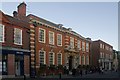
Former Library
Built in 1911 as a Carnegie Library. Carnegie Libraries were part funded by the Scottish-American businessman/philanthropist, among the conditions being that his contribution was matched by the community in which the library was built, who also had to provide the land - see http://en.wikipedia.org/wiki/Carnegie_library.
The building here was designed by local architect F G W Dudley, and followed the typical Carnegie formula of a grand entrance accesse by a flight of steps. It is locally listed.
It continued to house the City's public library until replaced in the 1980s by a new one in the Maltings development on the opposite side of Victoria Street. It is now an O'Neills Bar.
Image: © Ian Capper
Taken: 3 Dec 2011
0.02 miles
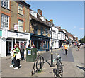
5
St Albans : St Peters Street
Looking along St Peters Street.
Image: © Lewis Clarke
Taken: 27 Apr 2019
0.02 miles
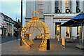
7
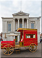
Engine in lights
A loose model of a steam engine bedecked with Christmas lights, as part of the city's Christmas decorations, situated in front of the former town hall at the head of St Peter's Street, now the city museum. Perhaps unsurprisingly, the challenge was taking the photo without children sitting in it and parents taking photos of said children.
Image: © Ian Capper
Taken: 4 Jan 2020
0.02 miles
8
O'Neill's, Victoria Street
Pub in a former Public Library
Image: © Keith Edkins
Taken: 1 Jun 2016
0.02 miles
9
Christmas feature near St Albans Museum
A seasonal contribution by the St Albans BID (Business Improvement District).
Image: © Robin Stott
Taken: 6 Dec 2022
0.03 miles
10
St Albans Market Place
St Albans Market Place is long. When the market is open, stalls are all the way along here to the trees in the distance.
Image: © Des Blenkinsopp
Taken: 23 Aug 2024
0.03 miles