IMAGES TAKEN NEAR TO
Remus Close, ST. ALBANS, AL1 2NR
Introduction
This page details the photographs taken nearby to Remus Close, AL1 2NR by members of the Geograph project.
The Geograph project started in 2005 with the aim of publishing, organising and preserving representative images for every square kilometre of Great Britain, Ireland and the Isle of Man.

There are currently over 7.5m images from over14,400 individuals and you can help contribute to the project by visiting https://www.geograph.org.uk
Image Map
Images are licensed for reuse under creativecommons.org/licenses/by-sa/2.0
Notes
- Clicking on the map will re-center to the selected point.
- The higher the marker number, the further away the image location is from the centre of the postcode.
Image Listing (10 Images Found)
Images are licensed for reuse under creativecommons.org/licenses/by-sa/2.0
Image
Details
Distance
1
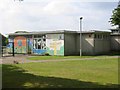
Mandeville Junior and Infants School in St Julians district
Prefab construction doesn't weather too well and so needs more loving care.
Image: © Jack Hill
Taken: 15 Aug 2005
0.11 miles
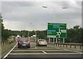
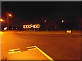
2
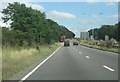
A414 - North Orbital
Always heavy traffic in this area, M1 and M25 feed into this stretch.
Image: © Fernweh
Taken: 5 Aug 2013
0.20 miles
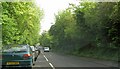
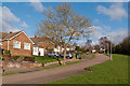
3
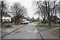
Path onto Abbots Avenue West
The path has come from Tavistock Avenue on an adjoining estate. It is viewed on a dull wet day.
Image: © Bill Boaden
Taken: 28 Feb 2020
0.20 miles
5
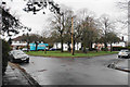
Green circle on Tavistock Avenue
A green enclave in the centre of the estate.
Image: © Bill Boaden
Taken: 28 Feb 2020
0.21 miles
6
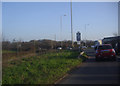
Queueing traffic on Watling Street St. Albans
Image: © Steve Fareham
Taken: 13 May 2010
0.22 miles
7
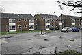
Flats on Watling View
Cordoned off by Heras fencing and presumably awaiting refurbishment.
Image: © Bill Boaden
Taken: 28 Feb 2020
0.22 miles
9
Roundabout on North Orbital Road, St Albans
Image: © David Howard
Taken: 14 Dec 2013
0.23 miles
10
Butt Field View
Part of a residential area developed around 1970 off St Julians Hill.
Image: © Ian Capper
Taken: 2 Feb 2013
0.24 miles