IMAGES TAKEN NEAR TO
Gorham Drive, ST. ALBANS, AL1 2HP
Introduction
This page details the photographs taken nearby to Gorham Drive, AL1 2HP by members of the Geograph project.
The Geograph project started in 2005 with the aim of publishing, organising and preserving representative images for every square kilometre of Great Britain, Ireland and the Isle of Man.

There are currently over 7.5m images from over14,400 individuals and you can help contribute to the project by visiting https://www.geograph.org.uk
Image Map
Images are licensed for reuse under creativecommons.org/licenses/by-sa/2.0
Notes
- Clicking on the map will re-center to the selected point.
- The higher the marker number, the further away the image location is from the centre of the postcode.
Image Listing (41 Images Found)
Images are licensed for reuse under creativecommons.org/licenses/by-sa/2.0
Image
Details
Distance
5

St Albans: The Abbey Flyer line
Viewed from the Abbotts Avenue bridge about a kilometre south of the St Albans Abbey terminus, the railway was built in 1858 by the London & North Western Railway and was the first line to be constructed into St Albans.
Image: © Nigel Cox
Taken: 11 May 2009
0.09 miles
7
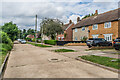
Butterfield Lane
Cul de sac off Cottonmill Lane, overlooking the River Ver watermeadows. Most of the houses date from the c.1950s.
Image: © Ian Capper
Taken: 5 Aug 2021
0.11 miles
8
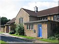
St Julian's C of E Church in Sopwell area
The church and hall are used for much social activities . The lady vicar is a hard worker.
Image: © Jack Hill
Taken: 15 Aug 2005
0.11 miles
9
Butterfield Lane
Cul de sac off Cottonmill Lane, overlooking the River Ver watermeadows. Most of the houses date from the c.1950s.
Image: © Ian Capper
Taken: 5 Aug 2021
0.12 miles
10
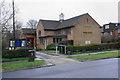
Church of St Julian
A daughter church in the parish of St Stephen.
Image: © Bill Boaden
Taken: 28 Feb 2020
0.12 miles