IMAGES TAKEN NEAR TO
Watsons Walk, ST. ALBANS, AL1 1PD
Introduction
This page details the photographs taken nearby to Watsons Walk, AL1 1PD by members of the Geograph project.
The Geograph project started in 2005 with the aim of publishing, organising and preserving representative images for every square kilometre of Great Britain, Ireland and the Isle of Man.

There are currently over 7.5m images from over14,400 individuals and you can help contribute to the project by visiting https://www.geograph.org.uk
Image Map
Images are licensed for reuse under creativecommons.org/licenses/by-sa/2.0
Notes
- Clicking on the map will re-center to the selected point.
- The higher the marker number, the further away the image location is from the centre of the postcode.
Image Listing (206 Images Found)
Images are licensed for reuse under creativecommons.org/licenses/by-sa/2.0
Image
Details
Distance
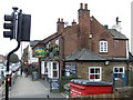
1
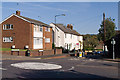
Old London Road
At its junction with Watsons Walk and Cottonmill Lane.
Image: © Ian Capper
Taken: 2 Oct 2011
0.03 miles
2
Old London Road at the junction of Cottonmill Lane
Image: © David Howard
Taken: 22 Jul 2014
0.04 miles
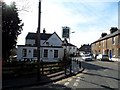
3
Kingdom Hall, Old London Road
Jehovah's Witness Kingdom Hall in Old London Road.
Image: © Ian Capper
Taken: 2 Oct 2011
0.05 miles
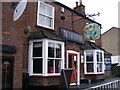
5
The Farmers Boy public house, St Albans
On London Road (A1081).
Image: © JThomas
Taken: 18 Mar 2017
0.06 miles
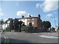
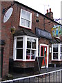
6
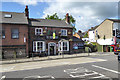
The Farmers Boy, St Albans
On London Road.
Image: © Robin Webster
Taken: 14 May 2017
0.06 miles
7
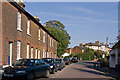
Sopwell Lane
Victorian terrace on Sopwell Lane as it leads into Old London Road. Locally listed.
Image: © Ian Capper
Taken: 2 Oct 2011
0.06 miles
8
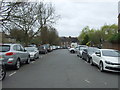
Keyfield Terrace, St Albans
Looking south west.
Image: © JThomas
Taken: 18 Mar 2017
0.06 miles
9
The Farmers Boy Public House
On the A1081 London Road
Image: © Geographer
Taken: 3 Jul 2012
0.06 miles
10
The Farmers Boy Public House
On the A1081 London Road
Image: © Geographer
Taken: 3 Jul 2012
0.06 miles