IMAGES TAKEN NEAR TO
Holywell Hill, ST. ALBANS, AL1 1HR
Introduction
This page details the photographs taken nearby to Holywell Hill, AL1 1HR by members of the Geograph project.
The Geograph project started in 2005 with the aim of publishing, organising and preserving representative images for every square kilometre of Great Britain, Ireland and the Isle of Man.

There are currently over 7.5m images from over14,400 individuals and you can help contribute to the project by visiting https://www.geograph.org.uk
Image Map
Images are licensed for reuse under creativecommons.org/licenses/by-sa/2.0
Notes
- Clicking on the map will re-center to the selected point.
- The higher the marker number, the further away the image location is from the centre of the postcode.
Image Listing (119 Images Found)
Images are licensed for reuse under creativecommons.org/licenses/by-sa/2.0
Image
Details
Distance
2
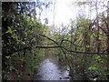
Footbridge by Holywell Hill, St Albans
The footbridge crosses the River Ver.
Image: © A J Paxton
Taken: 9 Apr 2022
0.03 miles
3
The King Harry Pub St Albans
This is an awkward junction with a double mini roundabout. Best avoided if possible. {see note re St Stephens Church}
Image: © Jack Hill
Taken: 15 Jul 2005
0.05 miles
4
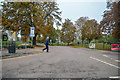
Holywell Hill looking towards Prospect Road
This was the A5 from central London but was then renumbered the A5183 from Edgware till Flamstead to deter drivers from using it. As they say, you couldn't make it up.
Image: © David Howard
Taken: 27 Aug 2015
0.05 miles
5
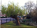
Pollarded willow by River Colne, Holywell Hill, St. Albans
Image: © A J Paxton
Taken: 13 Apr 2019
0.06 miles
6
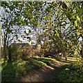
St Albans : Mud Lane
Mud Lane off of Holywell Hill.
Image: © Lewis Clarke
Taken: 4 Oct 2018
0.06 miles
7
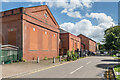
Holywell Pumping Station
Water pumping buildings in Holywell Hill. The nearest building, formerly the water company offices, dates from 1911 and now houses a nursery school. the other buildings, which are Edwardian, are still in use as a pumping station.
Image: © Ian Capper
Taken: 21 Aug 2020
0.06 miles
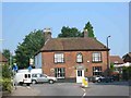
8
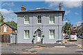
5 Grove Road
The former Duke of Marlborough pub, now 5 Grove Road following conversion to residential use in 2014. The building dates from the mid 19th century. Locally listed.
Image: © Ian Capper
Taken: 21 Aug 2020
0.07 miles
9
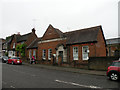
Former Water Company, Holywell Hill
Built 1908. Now Abbey View Nursery & Pre-school.
Image: © Keith Edkins
Taken: 1 Jun 2016
0.07 miles
10
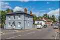
Holywell Hill
Looking up Holywell Hill, with the former Duke of Marlborough pub (now 5 Grove Road following conversion to residential use in 2014) on the left. All the buildings here date from the mid 19th century, with the row of cottages beyond being named Spencer Place in late 19th century maps.
Compare Image for a similar scene from 2011.
Near here, to the right of the present road at a point opposite the top end of the row of cottages, once stood Holywell House, a Tudor mansion the extension of whose gardens in the late 17th century led to the diversion of the original straight route of Holywell Hill to the west, to follow the route of what is now Grove Road, the start of which can be seen in front of the former pub and the end of which is beyond the cottages.
From 1684, the house was owned by John Churchill, later first Duke of Marlborough, who had come into its ownership following his marriage to Sarah Jennings. The Duke died in 1722, leaving Sarah as sole owner, who then in 1744 passed it to her grandson, John Spencer, who in turn passed it to his son, another John, who later became the first Earl Spencer of Althorp (from whom Lady Diana Spencer was descended).
The family stopped using the house in the early 19th century (although retaining ownership of various lands in and around St Albans, with road names such as Jennings Road, Althorp Road, Marlborough Road and Spencer Mews maintaining the connection). The house was demolished in 1837, and this enabled the corporation of St Albans to reinstate the direct route up Holywell Hill, as seen here. The name of the former pub and the former name of the cottages both commemorate the former owners of the estate.
Both the former pub and the cottages are locally listed.
Image: © Ian Capper
Taken: 21 Aug 2020
0.07 miles