IMAGES TAKEN NEAR TO
Deskford, BUCKIE, AB56 5YE
Introduction
This page details the photographs taken nearby to AB56 5YE by members of the Geograph project.
The Geograph project started in 2005 with the aim of publishing, organising and preserving representative images for every square kilometre of Great Britain, Ireland and the Isle of Man.

There are currently over 7.5m images from over14,400 individuals and you can help contribute to the project by visiting https://www.geograph.org.uk
Image Map
Images are licensed for reuse under creativecommons.org/licenses/by-sa/2.0
Notes
- Clicking on the map will re-center to the selected point.
- The higher the marker number, the further away the image location is from the centre of the postcode.
Image Listing (5 Images Found)
Images are licensed for reuse under creativecommons.org/licenses/by-sa/2.0
Image
Details
Distance
1
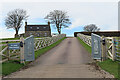
Pickwick Performance
The sign on the gate draws attention to a car sales business operating from here. see https://www.pickwickperformance.co.uk/ for details.
Image: © Anne Burgess
Taken: 16 Apr 2022
0.03 miles
2
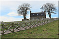
Fancy Fence
The fence along the driveway into Braeside is quite eye-catching.
Image: © Anne Burgess
Taken: 16 Apr 2022
0.03 miles
3
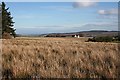
Braeside
Wet grazing land close to Tods Plantation. The house is Braeside.
Image: © Anne Burgess
Taken: 20 Feb 2007
0.18 miles
4
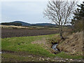
Ploughed Field near Swailend
The burn is unnamed, and rises from a spring just beside this field entrance. On the skyline is the Bin of Cullen.
Image: © Anne Burgess
Taken: 9 Mar 2021
0.20 miles
5
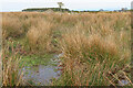
Upper Braeside
You can just about make out the remains of a gable poking up among the rushes. I had intended to go and get a closer view - until I saw the state of the ground inside the field.
Image: © Anne Burgess
Taken: 16 Apr 2022
0.21 miles