
IMAGES TAKEN NEAR TO
Earls View, BUCKIE, AB56 5RL
Introduction
This page details the photographs taken nearby to Earls View, AB56 5RL by members of the Geograph project.
The Geograph project started in 2005 with the aim of publishing, organising and preserving representative images for every square kilometre of Great Britain, Ireland and the Isle of Man.

There are currently over 7.5m images from over14,400 individuals and you can help contribute to the project by visiting https://www.geograph.org.uk
Image Map
Images are licensed for reuse under creativecommons.org/licenses/by-sa/2.0
Notes
- Clicking on the map will re-center to the selected point.
- The higher the marker number, the further away the image location is from the centre of the postcode.
Image Listing (20 Images Found)
Images are licensed for reuse under creativecommons.org/licenses/by-sa/2.0
Image
Details
Distance
1

Portgordon
New and newish houses in Prtgordon. The one on the slightly higher level are actually built on the trackbed of the former Great North of Scotland Railway.
Image: © Anne Burgess
Taken: 15 Jan 2021
0.05 miles
2

Cottage in Stewart Street
This cottage is permanently prepared for the next time the sea comes over the wall and floods the street. There is a note on the door directing deliveries to the side door.
Image: © Anne Burgess
Taken: 1 May 2009
0.05 miles
3

14 Stewart Street
The rear of Image] is just about as grotty as the front, but the garden has been comlpletely cleared so perhaps someone is about to take it in hand.
Image: © Anne Burgess
Taken: 30 Apr 2021
0.07 miles
4

14 Stewart Street ...
Image: © Anne Burgess
Taken: 10 Nov 2021
0.07 miles
5

14 Stewart Street
I think grotty is the only word to describe the state of this cottage.
Image: © Anne Burgess
Taken: 15 Jan 2021
0.07 miles
6

Stewart Street
Houses on Stewart Street, facing the sea.
Image: © Anne Burgess
Taken: 15 Jan 2021
0.09 miles
7
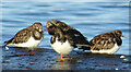
Turnstones (Arenia interpres)
These waders are quite common along this coast.
Image: © Anne Burgess
Taken: 15 Jan 2021
0.09 miles
8

Road junction, Portgordon
The A990 turns to the east (right), parallel to the coast. Stewart Street runs to the west (left).
Image: © Richard Sutcliffe
Taken: 25 Sep 2017
0.10 miles
9

Portgordon Bowling Club
The access to the club house, behind the sign, and the green, hidden by the hedge.
Image: © Anne Burgess
Taken: 10 Nov 2021
0.11 miles
10

The shore at Portgordon
On a fairly wild and blustery day.
Image: © David Purchase
Taken: 13 Jun 2019
0.11 miles