IMAGES TAKEN NEAR TO
Drybridge, BUCKIE, AB56 5JE
Introduction
This page details the photographs taken nearby to AB56 5JE by members of the Geograph project.
The Geograph project started in 2005 with the aim of publishing, organising and preserving representative images for every square kilometre of Great Britain, Ireland and the Isle of Man.

There are currently over 7.5m images from over14,400 individuals and you can help contribute to the project by visiting https://www.geograph.org.uk
Image Map
Images are licensed for reuse under creativecommons.org/licenses/by-sa/2.0
Notes
- Clicking on the map will re-center to the selected point.
- The higher the marker number, the further away the image location is from the centre of the postcode.
Image Listing (7 Images Found)
Images are licensed for reuse under creativecommons.org/licenses/by-sa/2.0
Image
Details
Distance
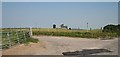
1

Rosebank
From the other side of the Back Burn.
Image: © Anne Burgess
Taken: 15 Apr 2021
0.03 miles
3
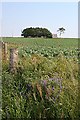
Rosebank
A field of neeps (swedes) below the farm house at Rosebank.
Image: © Anne Burgess
Taken: 19 Jul 2006
0.05 miles
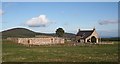
4
Hillhead
A traditional farm house, still occupied.
Image: © Anne Burgess
Taken: 20 Feb 2007
0.13 miles
5
Hillhead
A well-named farm with a magnificent view. To the north is the Bin of Cullen, and further east is the Moray Firth.
Image: © Anne Burgess
Taken: 20 Feb 2007
0.14 miles
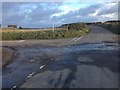
6
Hillhead
Hillhead is the farm on the skyline beyond the road junction.
Image: © Anne Burgess
Taken: 19 Jul 2006
0.14 miles
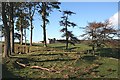
7
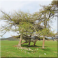
Twisted Larch
I suppose it's not surprising that a tree growing in such an exposed situation would show the effects of weather.
Image: © Anne Burgess
Taken: 16 Apr 2022
0.20 miles