IMAGES TAKEN NEAR TO
Cullen, BUCKIE, AB56 4SS
Introduction
This page details the photographs taken nearby to AB56 4SS by members of the Geograph project.
The Geograph project started in 2005 with the aim of publishing, organising and preserving representative images for every square kilometre of Great Britain, Ireland and the Isle of Man.

There are currently over 7.5m images from over14,400 individuals and you can help contribute to the project by visiting https://www.geograph.org.uk
Image Map
Images are licensed for reuse under creativecommons.org/licenses/by-sa/2.0
Notes
- Clicking on the map will re-center to the selected point.
- The higher the marker number, the further away the image location is from the centre of the postcode.
Image Listing (4 Images Found)
Images are licensed for reuse under creativecommons.org/licenses/by-sa/2.0
Image
Details
Distance
1
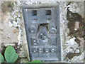
Ordnance Survey Flush Bracket G986
This can be found on the former railway bridge parapet.
For more detail see : http://www.bench-marks.org.uk/bm16940
Image: © Peter Wood
Taken: 5 Oct 2012
0.08 miles
2
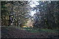
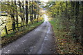
Forest Track
This is the track straight ahead; the waymarked path turns left at this point. In bygone years this was a main route from Cullen to Sandend, but it has now been bypassed twice; once by the old A98 and again by the realigned A98.
Image: © Anne Burgess
Taken: 20 Jan 2011
0.16 miles
3
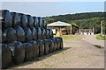
Silage Storage at Tochieneal
There is a large number of black-wrapped bales across the road from the steading at Tochieneal. In the background are Tochieneal Cottages.
Image: © Anne Burgess
Taken: 17 Sep 2008
0.22 miles