IMAGES TAKEN NEAR TO
AB56 2HP
Introduction
This page details the photographs taken nearby to AB56 2HP by members of the Geograph project.
The Geograph project started in 2005 with the aim of publishing, organising and preserving representative images for every square kilometre of Great Britain, Ireland and the Isle of Man.

There are currently over 7.5m images from over14,400 individuals and you can help contribute to the project by visiting https://www.geograph.org.uk
Image Map
Images are licensed for reuse under creativecommons.org/licenses/by-sa/2.0
Notes
- Clicking on the map will re-center to the selected point.
- The higher the marker number, the further away the image location is from the centre of the postcode.
Image Listing (3 Images Found)
Images are licensed for reuse under creativecommons.org/licenses/by-sa/2.0
Image
Details
Distance
1
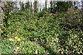
Cowfurrach
There is indeed a ruin lurking among the ivy - its corrugated iron roof is just visible.
Image: © Anne Burgess
Taken: 20 Mar 2007
0.23 miles
2
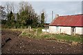
Cowfurrach
The map suggests that there was a house among the trees and ivy to the left here.
Image: © Anne Burgess
Taken: 20 Mar 2007
0.25 miles
3
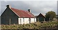
Cowfurrach
This seems to be the only old cottage at Cowfurrach which still survives.
Image: © Anne Burgess
Taken: 20 Mar 2007
0.25 miles