IMAGES TAKEN NEAR TO
Police Lane, BUCKIE, AB56 1RG
Introduction
This page details the photographs taken nearby to Police Lane, AB56 1RG by members of the Geograph project.
The Geograph project started in 2005 with the aim of publishing, organising and preserving representative images for every square kilometre of Great Britain, Ireland and the Isle of Man.

There are currently over 7.5m images from over14,400 individuals and you can help contribute to the project by visiting https://www.geograph.org.uk
Image Map
Images are licensed for reuse under creativecommons.org/licenses/by-sa/2.0
Notes
- Clicking on the map will re-center to the selected point.
- The higher the marker number, the further away the image location is from the centre of the postcode.
Image Listing (34 Images Found)
Images are licensed for reuse under creativecommons.org/licenses/by-sa/2.0
Image
Details
Distance
1

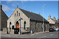
Gospel Hall
I am told that this Gospel Hall is Brethren. (Open Brethren not the Exclusive or Close Brethren). Brethren do not self-identify as a denomination which is why they would not use a label of themselves.
I have note been able to find out when it was built, or by whom.
It is on the north side of West Church Street. See http://www.scottishchurches.org.uk/sites/site/id/3106/name/Gospel+Hall%2C+Buckie+Buckie+Grampian
Image: © Anne Burgess
Taken: 8 Apr 2014
0.08 miles
2

Chinatown Restaurant
This was for a time Buckie's one and only Tandoori restaurant, but it has been a Chinese for many years now.
Image: © Anne Burgess
Taken: 8 Apr 2014
0.09 miles
3
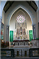
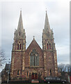
St Peter's Church
Sometimes, and inaccurately, referred to as a cathedral, this is the main Roman Catholic church in the parish of Rathven. St Gregory's at Preshome and St Ninian's at Tynet are served from here. The church was built in 1851-7 to a design by Bishop James Kyle and Alexander and William Reid. In 1907 the chancel, altar and baptistry were altered by Charles Jean Ménart.
Image: © Anne Burgess
Taken: 26 Aug 2009
0.11 miles
5
Church of Christ
The 1902 25-inch Ordnance Survey map marks this little church as a Baptist chapel. It was superseded by Image] in 1912. It is now one of only two Church of Christ churches in Scotland, the other being just a few miles away in Portknockie.
Image: © Anne Burgess
Taken: 8 Apr 2014
0.13 miles
6
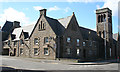
Pringle Court
Despite its vaguely ecclesiastical look, this was originally Buckie Public School. It was built by Rathven School Board after the 1872 Education (Scotland) Act made education from the age of 5 to 13 compulsory and free. Over the next century the school expanded to take in older children and pupils from surrounding areas, then contracted as it was replaced by new buildings, leaving only a few subjects still being taught in the old one. In 1983 it finally became surplus to edcuational requirements and has been converted into flats.
Image: © Anne Burgess
Taken: 8 Apr 2014
0.13 miles

9
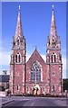
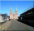
St Peter's Church
This is Buckie's Roman Catholic church, built in 1857.
Image: © Anne Burgess
Taken: 21 Jul 1983
0.13 miles
10
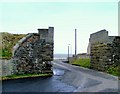
Topless
This bridge formed part of the former railway line between Portgordon and
Buckie.The top was removed to facilitate the access to the poultry plant
by high sided vehicles.
Image: © Ann Harrison
Taken: 20 Mar 2008
0.14 miles