IMAGES TAKEN NEAR TO
East Church Street, BUCKIE, AB56 1LR
Introduction
This page details the photographs taken nearby to East Church Street, AB56 1LR by members of the Geograph project.
The Geograph project started in 2005 with the aim of publishing, organising and preserving representative images for every square kilometre of Great Britain, Ireland and the Isle of Man.

There are currently over 7.5m images from over14,400 individuals and you can help contribute to the project by visiting https://www.geograph.org.uk
Image Map
Images are licensed for reuse under creativecommons.org/licenses/by-sa/2.0
Notes
- Clicking on the map will re-center to the selected point.
- The higher the marker number, the further away the image location is from the centre of the postcode.
Image Listing (119 Images Found)
Images are licensed for reuse under creativecommons.org/licenses/by-sa/2.0
Image
Details
Distance
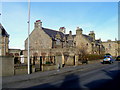
1
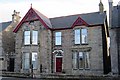
Preston Villa
This house, dating from 1897, is one of the few in Buckie to merit a mention in 'The Buildings of Scotland'. Sadly, the 'fine original cast-iron gate' that drew the authors' attention seems to have disappeared.
Image: © Anne Burgess
Taken: 13 Oct 2017
0.02 miles
2
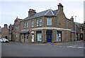
Funeral Directors
Frank S. McLean & Son, Funeral Directors, at the corner of East Church Street and Harbour Street, Buckie.
Image: © Richard Sutcliffe
Taken: 18 Oct 2023
0.02 miles
3
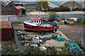
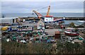
Out of the water
Buckie-registered fishing boat BCK333 Saorsa on blocks for maintenance of some kind, just south of the harbour.
Image: © Richard Sutcliffe
Taken: 18 Oct 2023
0.03 miles
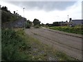
4
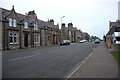
Houses on East Church Street, Buckie
Image: © Richard Sutcliffe
Taken: 18 Oct 2023
0.04 miles
5
Looking down on the harbour
A view from a viewpoint off East Church Street over the western end of Buckie Harbour. The large ship is the MV Treville Image
Image: © Richard Sutcliffe
Taken: 18 Oct 2023
0.04 miles
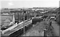
7
Buckie GNS railway station (site), Moray
Opened in 1886 by the Great North of Scotland Railway on the line from Tillynaught to Elgin, this station closed in 1968 and was largely demolished.
View south west towards Buckpool and Elgin. The support for the footbridge was still in place when this image was taken, which can be seen looking in the opposite direction some 58 years previously on Image A footpath now runs through the site.
Image: © Nigel Thompson
Taken: 5 Sep 2019
0.06 miles
8
Buckie (GNS) Station
View eastward, towards Portessie, Cullen and eventually round to Cairnie Junction; ex-Great North of Scotland line, Cairnie Junction via coast to Elgin, closed completely on 6/5/68. (Until 9/8/15 there had been another Buckie Station (off to the right) on a Highland Rly branch from Keith to Portessie).
Image: © Ben Brooksbank
Taken: 2 Oct 1961
0.06 miles
9
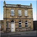
Former Register Office
This building was originally the General Register Office, built in 1920-1921.
Image: © Anne Burgess
Taken: 13 Oct 2017
0.06 miles
10
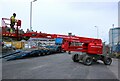
Mobile platform
The mobile platform had just been unloaded from the low-loader on the other side of the road and was being driven into the area beside the harbour.
Image: © Richard Sutcliffe
Taken: 18 Oct 2023
0.06 miles