IMAGES TAKEN NEAR TO
Mulben, KEITH, AB55 6YN
Introduction
This page details the photographs taken nearby to AB55 6YN by members of the Geograph project.
The Geograph project started in 2005 with the aim of publishing, organising and preserving representative images for every square kilometre of Great Britain, Ireland and the Isle of Man.

There are currently over 7.5m images from over14,400 individuals and you can help contribute to the project by visiting https://www.geograph.org.uk
Image Map
Images are licensed for reuse under creativecommons.org/licenses/by-sa/2.0
Notes
- Clicking on the map will re-center to the selected point.
- The higher the marker number, the further away the image location is from the centre of the postcode.
Image Listing (5 Images Found)
Images are licensed for reuse under creativecommons.org/licenses/by-sa/2.0
Image
Details
Distance
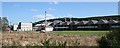
1
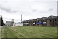
Garland
A large mixed farm. There are cattle in the barns, and presumably the grass is being grown for hay or silage. The cottage further up the hill, to the right, is Easter Garland. In the foreground is the Aberdeen to Inverness railway line.
Image: © Anne Burgess
Taken: 27 Apr 2007
0.01 miles
2
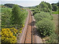
Tauchers Halt railway station (site), Moray
Believed to have been opened here by the London Midland and Scottish Railway in the 1920s (needs confirmation) on the line from Keith to Inverness, this station closed in 1964. The line was later singled.
View east towards Keith Junction. Out of view to the right is the Glentauchers Distillery which had its own short branch line for goods.
Image: © Nigel Thompson
Taken: 26 May 2017
0.17 miles
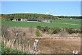
3
Railway bridge to the north of Glentauchers Distillery
Image: © Des Colhoun
Taken: 7 Aug 2006
0.21 miles
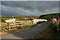
4
Glentauchers Distillery
From the side road to Garland.
Image: © Anne Burgess
Taken: 27 Apr 2007
0.25 miles