IMAGES TAKEN NEAR TO
Mulben, KEITH, AB55 6YJ
Introduction
This page details the photographs taken nearby to AB55 6YJ by members of the Geograph project.
The Geograph project started in 2005 with the aim of publishing, organising and preserving representative images for every square kilometre of Great Britain, Ireland and the Isle of Man.

There are currently over 7.5m images from over14,400 individuals and you can help contribute to the project by visiting https://www.geograph.org.uk
Image Map
Images are licensed for reuse under creativecommons.org/licenses/by-sa/2.0
Notes
- Clicking on the map will re-center to the selected point.
- The higher the marker number, the further away the image location is from the centre of the postcode.
Image Listing (4 Images Found)
Images are licensed for reuse under creativecommons.org/licenses/by-sa/2.0
Image
Details
Distance
1
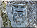
Ordnance Survey Flush Bracket S7113
This can be found on the former Blackhillock Church - now apartments.
Image: © Peter Wood
Taken: 4 Oct 2012
0.19 miles
2
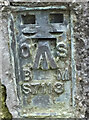
Flush Bracket OSBM S7113, Mulben on former church
Flush Bracket OSBM S7113, Mulben on former church now apartments
Image: © thejackrustles
Taken: 24 Jan 2015
0.20 miles
3
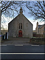
Former Church, Mulben
Former Church, Mulben now apartments
Image: © thejackrustles
Taken: 24 Jan 2015
0.20 miles
4
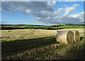
Bales and Shadows
A pair of bales awaits uplifting beside the shadows of trees on the field boundary.
Image: © Anne Burgess
Taken: 22 Sep 2022
0.25 miles