IMAGES TAKEN NEAR TO
Mulben, KEITH, AB55 6YH
Introduction
This page details the photographs taken nearby to AB55 6YH by members of the Geograph project.
The Geograph project started in 2005 with the aim of publishing, organising and preserving representative images for every square kilometre of Great Britain, Ireland and the Isle of Man.

There are currently over 7.5m images from over14,400 individuals and you can help contribute to the project by visiting https://www.geograph.org.uk
Image Map
Images are licensed for reuse under creativecommons.org/licenses/by-sa/2.0
Notes
- Clicking on the map will re-center to the selected point.
- The higher the marker number, the further away the image location is from the centre of the postcode.
Image Listing (12 Images Found)
Images are licensed for reuse under creativecommons.org/licenses/by-sa/2.0
Image
Details
Distance
1
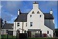
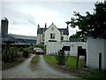
The House of Mulben
This laird's house dates from 1696, according to the left-hand pane high on the gable, and the right-hand panel bears the initial of its builder, Ludovick Grant, 1st Baronet, and his wife Janet Brodie.
Image: © Anne Burgess
Taken: 10 Oct 2017
0.00 miles
2
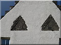
Detail of Dormerheads
These triangular panels look a little odd, perhaps because they were originally above windows that were removed at some point, and re-sited on the east gable.
Image: © Anne Burgess
Taken: 10 Oct 2017
0.00 miles
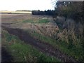
3
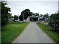
Mains of Mulben Farm.
Farmhouse at Mains of Mulben. This farmhouse departs from the traditional Scottish design.
Image: © Christopher Gillan
Taken: 8 Aug 2006
0.01 miles
4
Mains of Mulben Farm.
Steading at Mains of Mulben Farm.
Image: © Christopher Gillan
Taken: 8 Aug 2006
0.01 miles
5

Slates
Old slates create an abstract pattern of light and shade at Mains of Mulben.
Image: © Anne Burgess
Taken: 10 Oct 2017
0.02 miles
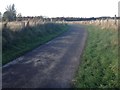
6
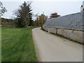
Minor road passing the Mains of Mulben
Looking westward.
Image: © Peter Wood
Taken: 25 Oct 2018
0.02 miles
7
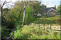
Malcolm Burn and Mills of Mulben
The Malcolm Burn flows beneath the bridge here to join the Burn of Mulben in the pool at lower left. The building is one of several collectively marked on the maps as Mills of Mulben, though the sign on the gate says Mill Croft.
Image: © Anne Burgess
Taken: 10 Oct 2017
0.05 miles
8
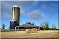
Mains of Mulben
Silos and sheds at Mains of Mulben.
Image: © Anne Burgess
Taken: 10 Oct 2017
0.06 miles