IMAGES TAKEN NEAR TO
Mulben, KEITH, AB55 6XY
Introduction
This page details the photographs taken nearby to AB55 6XY by members of the Geograph project.
The Geograph project started in 2005 with the aim of publishing, organising and preserving representative images for every square kilometre of Great Britain, Ireland and the Isle of Man.

There are currently over 7.5m images from over14,400 individuals and you can help contribute to the project by visiting https://www.geograph.org.uk
Image Map
Images are licensed for reuse under creativecommons.org/licenses/by-sa/2.0
Notes
- Clicking on the map will re-center to the selected point.
- The higher the marker number, the further away the image location is from the centre of the postcode.
Image Listing (6 Images Found)
Images are licensed for reuse under creativecommons.org/licenses/by-sa/2.0
Image
Details
Distance
1
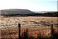
Shalloch
Looking down to Shalloch from the back road. The farm buildings are partly hidden in the shade at the edge of the woods. The hill on the skyline is Knockmore.
Image: © Anne Burgess
Taken: 5 Jan 2009
0.06 miles
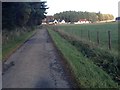
3
Cottage at Shalloch near Mulben.
This cottage is situated at Shalloch near Mulben. Ben Rinnes is seen in the top left corner of the photo. The collie dog was watching my every move!!
Image: © Christopher Gillan
Taken: 8 Aug 2006
0.11 miles
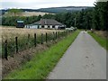
4
Minor road approaching Shalloch
Looking north-eastward.
Image: © Peter Wood
Taken: 25 Oct 2018
0.17 miles
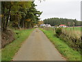
5
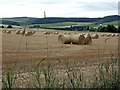
Harvest scene near Shalloch by Mulben.
Early autumnal scene captured in the second week of August.
Image: © Christopher Gillan
Taken: 8 Aug 2006
0.22 miles
6
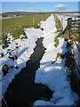
Drainage Ditch
The ditch has been filled in by recent heavy snow but as the temperature rises it is beginning to emerge as the snow melts.
Image: © Anne Burgess
Taken: 7 Mar 2018
0.24 miles