IMAGES TAKEN NEAR TO
Craighead, KEITH, AB55 6XR
Introduction
This page details the photographs taken nearby to Craighead, AB55 6XR by members of the Geograph project.
The Geograph project started in 2005 with the aim of publishing, organising and preserving representative images for every square kilometre of Great Britain, Ireland and the Isle of Man.

There are currently over 7.5m images from over14,400 individuals and you can help contribute to the project by visiting https://www.geograph.org.uk
Image Map
Images are licensed for reuse under creativecommons.org/licenses/by-sa/2.0
Notes
- Clicking on the map will re-center to the selected point.
- The higher the marker number, the further away the image location is from the centre of the postcode.
Image Listing (2 Images Found)
Images are licensed for reuse under creativecommons.org/licenses/by-sa/2.0
Image
Details
Distance
1
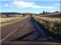
Mulben in the Sunshine
The barn in the left middle ground, beyond the rather unhappy-looking roadside trees, belongs to Shalloch, as does the low building at lower right. At extreme upper left is Stoneyton, with Craighead on the roadside below it. Higher up, and to the right, are new houses called Cummingston, Mayar and Hillcrest. On the right is the slope up to Knockmore. Bales left in the fields since last harvest are picked out against the snow.
Image: © Anne Burgess
Taken: 7 Mar 2018
0.08 miles