IMAGES TAKEN NEAR TO
Mulben, KEITH, AB55 6XP
Introduction
This page details the photographs taken nearby to AB55 6XP by members of the Geograph project.
The Geograph project started in 2005 with the aim of publishing, organising and preserving representative images for every square kilometre of Great Britain, Ireland and the Isle of Man.

There are currently over 7.5m images from over14,400 individuals and you can help contribute to the project by visiting https://www.geograph.org.uk
Image Map
Images are licensed for reuse under creativecommons.org/licenses/by-sa/2.0
Notes
- Clicking on the map will re-center to the selected point.
- The higher the marker number, the further away the image location is from the centre of the postcode.
Image Listing (11 Images Found)
Images are licensed for reuse under creativecommons.org/licenses/by-sa/2.0
Image
Details
Distance
1
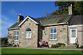
Former School
The school is marked on the First Edition of the six-inch Ordnance Survey map, so obviously dates from before the survey in 1870. Now a private house, it has been extended and renamed Balnagreen. If this is from the Gaelic Baile na Greine, it is well chosen, because it means something like' sunny place' and it has a magnificent view across the glen.
Image: © Anne Burgess
Taken: 10 Oct 2017
0.01 miles
2
Hollybank
The red notice says that the place is guarded by Mastino (Neapolitan Mastiff) guard dogs, and advising anyone approached to stay calm, not raise their voice, and wait for the handler. Having read a bit about them, and being nervous of large dogs, I am glad that I had not ventured to stray from the refuge of my car; some dogs of this breed are heavier than I am and they can be aggressive towards strangers.
Image: © Anne Burgess
Taken: 10 Oct 2017
0.03 miles
3
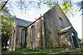
Former Boharm Parish Kirk (2)
This kirk is easily overlooked because it is hidden by a patch of woodland that also shades the building and makes it difficult to photograph. It was originally a plain rectangle built in the 1790s to replace Image The east porch, seen here, and a vestry on the west, both by William Robertson, were added in 1828. The south aisle, by John Alcock, was added in 1899, making the main part of the building into a T-plan. The church closed in 1974. Image]
Image: © Anne Burgess
Taken: 10 Oct 2017
0.03 miles
4
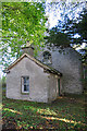
Former Boharm Parish Kirk (3)
This kirk is easily overlooked because it is hidden by a patch of woodland that also shades the building and makes it difficult to photograph. It was originally a plain rectangle built in the 1790s to replace Image The vestry with round-headed window, seen here, and a porch on the west, both by William Robertson, were added in 1828. The low extension is later still. On top of the west gable, partly visible through the foliage, is a birdcage bellcote added in 1883 by Matthews and Mackenzie. The church closed in 1974. Image]
Image: © Anne Burgess
Taken: 10 Oct 2017
0.03 miles
5
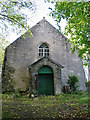
Former Boharm Parish Kirk (1)
This kirk is easily overlooked because it is hidden by a patch of woodland that also shades the building and makes it difficult to photograph. It was originally a plain rectangle built in the 1790s to replace Image The east porch, seen here, and a vestry on the west, both by William Robertson, were added in 1828. The church closed in 1974. Image]
Image: © Anne Burgess
Taken: 10 Oct 2017
0.04 miles
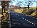
6
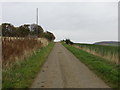
Minor road approaching Hollybank
Looking north-eastward.
Image: © Peter Wood
Taken: 25 Oct 2018
0.05 miles
7
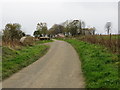
Minor road near Balnabreich
Looking south-westward.
Image: © Peter Wood
Taken: 25 Oct 2018
0.11 miles
10
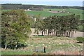
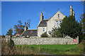
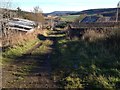
Auchlunkart
Mixed arable and woodland is characteristic of the lower ground here. The farms on the hill are Hollybank of the left and Balnabreich on the right.
Image: © Anne Burgess
Taken: 27 Apr 2007
0.16 miles