IMAGES TAKEN NEAR TO
Mulben, KEITH, AB55 6XN
Introduction
This page details the photographs taken nearby to AB55 6XN by members of the Geograph project.
The Geograph project started in 2005 with the aim of publishing, organising and preserving representative images for every square kilometre of Great Britain, Ireland and the Isle of Man.

There are currently over 7.5m images from over14,400 individuals and you can help contribute to the project by visiting https://www.geograph.org.uk
Image Map
Images are licensed for reuse under creativecommons.org/licenses/by-sa/2.0
Notes
- Clicking on the map will re-center to the selected point.
- The higher the marker number, the further away the image location is from the centre of the postcode.
Image Listing (3 Images Found)
Images are licensed for reuse under creativecommons.org/licenses/by-sa/2.0
Image
Details
Distance
1
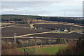
Ardoch
The recently ploughed fields around Ardoch are picked out by wide unploughed margins. Above the farmland is Mount Pleasant, part of Rosarie Forest, and Hill of Towie wind farm is on the top of the hill.
Image: © Anne Burgess
Taken: 5 Mar 2021
0.04 miles
2
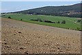
Ardoch
Another arable farm. Presumably the field in the foreground has been sown too recently for the crop to have sprouted yet.
Image: © Anne Burgess
Taken: 27 Apr 2007
0.06 miles
3
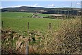
Ardoch
The hill on the skyline is Ben Aigen.
Image: © Anne Burgess
Taken: 27 Apr 2007
0.06 miles