IMAGES TAKEN NEAR TO
Newmill, KEITH, AB55 6XH
Introduction
This page details the photographs taken nearby to AB55 6XH by members of the Geograph project.
The Geograph project started in 2005 with the aim of publishing, organising and preserving representative images for every square kilometre of Great Britain, Ireland and the Isle of Man.

There are currently over 7.5m images from over14,400 individuals and you can help contribute to the project by visiting https://www.geograph.org.uk
Image Map
Images are licensed for reuse under creativecommons.org/licenses/by-sa/2.0
Notes
- Clicking on the map will re-center to the selected point.
- The higher the marker number, the further away the image location is from the centre of the postcode.
Image Listing (6 Images Found)
Images are licensed for reuse under creativecommons.org/licenses/by-sa/2.0
Image
Details
Distance
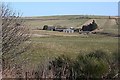
1
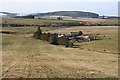
Burns of Kinminitie
The topography of the Kinminitie Burn is more evident from this angle. It flows down through the farm, and is joined by a tributary from Followsters in the deep gully beyond. The hill in the background is the Hill of Muldearie.
Image: © Anne Burgess
Taken: 6 Mar 2009
0.02 miles
2
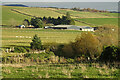
Burns of Kinminitie
One of the nuemrous farms and crofts north of Newmill, though many of its neighbours have disappeared from the map.
Image: © Anne Burgess
Taken: 9 Nov 2020
0.05 miles
3
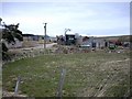
Burns of Kinminitie
Farm Buildings at Burns of Kinminitie.
Image: © Christopher Gillan
Taken: 15 Apr 2006
0.06 miles
4
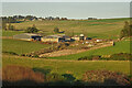
Burns of Kinminitie
The farm is on the far side of the burn's gully from Guilyknowes.
Image: © Anne Burgess
Taken: 6 Nov 2020
0.07 miles
5
Burns of Kinminitie
Not surprisingly, Burns of Kinminitie lies right on the Kinminitie Burn, at the lowest point of the broad shallow glen.
Image: © Anne Burgess
Taken: 6 Mar 2009
0.09 miles
6
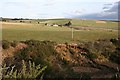
Erosion
This deep gully has been formed by run-off. The red colour of the soil shows up well in the low January sunshine. The farm beyond is Burns of Kinminitie.
Image: © Anne Burgess
Taken: 15 Jan 2007
0.24 miles