IMAGES TAKEN NEAR TO
Newmill, KEITH, AB55 6XE
Introduction
This page details the photographs taken nearby to AB55 6XE by members of the Geograph project.
The Geograph project started in 2005 with the aim of publishing, organising and preserving representative images for every square kilometre of Great Britain, Ireland and the Isle of Man.

There are currently over 7.5m images from over14,400 individuals and you can help contribute to the project by visiting https://www.geograph.org.uk
Image Map
Images are licensed for reuse under creativecommons.org/licenses/by-sa/2.0
Notes
- Clicking on the map will re-center to the selected point.
- The higher the marker number, the further away the image location is from the centre of the postcode.
Image Listing (4 Images Found)
Images are licensed for reuse under creativecommons.org/licenses/by-sa/2.0
Image
Details
Distance
1
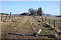
Near Broomhill
The track to this farm, name unknown, has not been much in use recently. The fence posts are part of a sheep-proof fence across the end of the track, presumably flattened temporarily for access.
Image: © Anne Burgess
Taken: 6 Mar 2009
0.01 miles
2
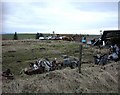
Car Graveyard near Broomhill, Newmill
Lots of rusting automobile parts!!!
Image: © Christopher Gillan
Taken: 15 Apr 2006
0.12 miles
3
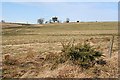
Broomhill
Broomhill stands in an exposed position, though it isn't the highest farm in this area.
Image: © Anne Burgess
Taken: 6 Mar 2009
0.19 miles
4
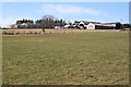
Broadrashes
Broadrashes is an area rather than an individual farm, and this is one of several which share the name.
Image: © Anne Burgess
Taken: 6 Mar 2009
0.20 miles