IMAGES TAKEN NEAR TO
Newmill, KEITH, AB55 6XA
Introduction
This page details the photographs taken nearby to AB55 6XA by members of the Geograph project.
The Geograph project started in 2005 with the aim of publishing, organising and preserving representative images for every square kilometre of Great Britain, Ireland and the Isle of Man.

There are currently over 7.5m images from over14,400 individuals and you can help contribute to the project by visiting https://www.geograph.org.uk
Image Map
Images are licensed for reuse under creativecommons.org/licenses/by-sa/2.0
Notes
- Clicking on the map will re-center to the selected point.
- The higher the marker number, the further away the image location is from the centre of the postcode.
Image Listing (3 Images Found)
Images are licensed for reuse under creativecommons.org/licenses/by-sa/2.0
Image
Details
Distance
1
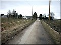
Newtonbrae Farm, Newmill
Newtonbrae Farm seen from the access road from the south.
Image: © Christopher Gillan
Taken: 15 Apr 2006
0.01 miles
2
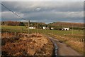
The Road to Newtonbrae
Newtonbrae is at the end of the tarmac public road.
Image: © Anne Burgess
Taken: 15 Jan 2007
0.07 miles
3
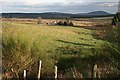
Sunnybrae
The hollow below the farm is the course of the Burn of Sunnybrae, which flows east (away from the photographer's position) to join the Garral Burn and eventually the River Isla. The hill in the distance is Knock Hill.
Image: © Anne Burgess
Taken: 15 Jan 2007
0.21 miles