IMAGES TAKEN NEAR TO
Newmill, KEITH, AB55 6UN
Introduction
This page details the photographs taken nearby to AB55 6UN by members of the Geograph project.
The Geograph project started in 2005 with the aim of publishing, organising and preserving representative images for every square kilometre of Great Britain, Ireland and the Isle of Man.

There are currently over 7.5m images from over14,400 individuals and you can help contribute to the project by visiting https://www.geograph.org.uk
Image Map
Images are licensed for reuse under creativecommons.org/licenses/by-sa/2.0
Notes
- Clicking on the map will re-center to the selected point.
- The higher the marker number, the further away the image location is from the centre of the postcode.
Image Listing (4 Images Found)
Images are licensed for reuse under creativecommons.org/licenses/by-sa/2.0
Image
Details
Distance
1
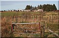
Deerhill Farm
Deerhill is a large and well-maintained farm. In the foreground is a plantation of native broadleaved species beside the Tarryfeuch Burn, which crosses the track here at a ford. Fortunately there is a tiny footbridge too!
Image: © Anne Burgess
Taken: 19 Jan 2007
0.02 miles
2
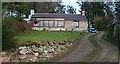
Tarryfeuch
An attractively restored farm house which must have a magnificent view from the conservatory.
Image: © Anne Burgess
Taken: 19 Jan 2007
0.13 miles
3
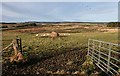
Horsebog
Looking across the pasture at Horsebog Farm towards young plantations of both conifers and broadleaved trees.
Image: © Anne Burgess
Taken: 19 Jan 2007
0.24 miles
4
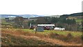
Burn of Aultmore
One of the three farms named Burn of Aultmore. In the far distance are the Conval Hills near Dufftown, with the first snow cover of 2007.
Image: © Anne Burgess
Taken: 19 Jan 2007
0.25 miles