IMAGES TAKEN NEAR TO
Newmill, KEITH, AB55 6UL
Introduction
This page details the photographs taken nearby to AB55 6UL by members of the Geograph project.
The Geograph project started in 2005 with the aim of publishing, organising and preserving representative images for every square kilometre of Great Britain, Ireland and the Isle of Man.

There are currently over 7.5m images from over14,400 individuals and you can help contribute to the project by visiting https://www.geograph.org.uk
Image Map
Images are licensed for reuse under creativecommons.org/licenses/by-sa/2.0
Notes
- Clicking on the map will re-center to the selected point.
- The higher the marker number, the further away the image location is from the centre of the postcode.
Image Listing (9 Images Found)
Images are licensed for reuse under creativecommons.org/licenses/by-sa/2.0
Image
Details
Distance
1

Cranesbill
A large patch of bright flowers by the roadside.
Image: © Anne Burgess
Taken: 28 Jun 2007
0.02 miles
2
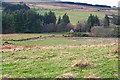
Burn of Aultmore
The gable end just visible among the trees is one of three farms in the vicinity, all named Burn of Aultmore. The others are in Image
Image: © Anne Burgess
Taken: 19 Jan 2007
0.02 miles
3
Burn of Aultmore
The gable end of the old cottage is lit by early morning sunshine. Once the leaves come out on the trees, it's difficult to see this farm at all.
Image: © Anne Burgess
Taken: 27 Apr 2008
0.02 miles
4
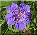
Cranesbill
It isn't Meadow Cranesbill (Geranium pratense) because the petals are notched. Compare with Image] HoweverI can't decide whether it's Wood Cranesbill (G sylvaticum) or Purple Cranesbill (G x magnificum).
Image: © Anne Burgess
Taken: 28 Jun 2007
0.02 miles
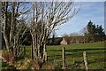
5
Burn of Aultmore Croft Bothy
The bothy has been refurbished and, like the main house nearby, is available for holiday lets. The old maps show this as Thievesbush, but the modern maps show Thievesbush a little further up the side of the burn.
Image: © Anne Burgess
Taken: 8 Oct 2020
0.03 miles
6
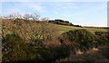
Burn of Aultmore
Looking across the burn to farmland on the hill beyond.
Image: © Anne Burgess
Taken: 17 Jan 2007
0.13 miles
7
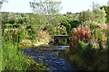
Burn of Aultmore
A ford and footbridge give access to the farms on the east side of the Burn of Aultmore.
Image: © Anne Burgess
Taken: 8 Oct 2020
0.18 miles
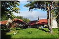
8
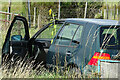
An Improvised Greenhouse
Did the sunflower seed itself, or was it put there in a pot?
Image: © Anne Burgess
Taken: 19 Aug 2022
0.24 miles
9
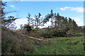
Storm Damage
Presumably the aftermath of last November's Storm Arwen.
Image: © Anne Burgess
Taken: 18 Apr 2022
0.24 miles