IMAGES TAKEN NEAR TO
Hill Street, KEITH, AB55 6TY
Introduction
This page details the photographs taken nearby to Hill Street, AB55 6TY by members of the Geograph project.
The Geograph project started in 2005 with the aim of publishing, organising and preserving representative images for every square kilometre of Great Britain, Ireland and the Isle of Man.

There are currently over 7.5m images from over14,400 individuals and you can help contribute to the project by visiting https://www.geograph.org.uk
Image Map
Images are licensed for reuse under creativecommons.org/licenses/by-sa/2.0
Notes
- Clicking on the map will re-center to the selected point.
- The higher the marker number, the further away the image location is from the centre of the postcode.
Image Listing (52 Images Found)
Images are licensed for reuse under creativecommons.org/licenses/by-sa/2.0
Image
Details
Distance
1
Hill Street
Looking down from the top of the street towards the Square with its distinctive clock tower. There is a glimpse of the town of Keith beyond, and the hill on the left is Meikle Balloch.
Image: © Anne Burgess
Taken: 12 Mar 2009
0.01 miles
2

Colourful Wall
The walls of the older houses in Newmill are built of a wide variety of different stone, including granite, schist and quartzite.
Image: © Anne Burgess
Taken: 3 May 2021
0.02 miles
3
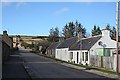
Hill Street
Old cottages on the east side of Hill Street. The old road goes direct up the hill to Hillhead; the metalled road diverges to the left.
Image: © Anne Burgess
Taken: 12 Mar 2009
0.04 miles
4
The Dogwatch
According to the name on the letterbox, the name of this curious cottage is The Dogwatch. It is the first house at the top of Hill Street. The shadow is that of Kimberley House across the street.
Image: © Anne Burgess
Taken: 12 Mar 2009
0.06 miles
5
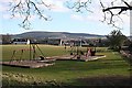
Playground
A well-appointed playground, deserted in this schoolday afternoon. The houses are the east end of Main Street, and the hill on the Skyline is Meikle Balloch.
Image: © Anne Burgess
Taken: 12 Mar 2009
0.07 miles
6
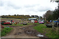
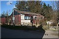
Farm Machinery Storage
On the outskirts of Newmill.
Image: © Anne Burgess
Taken: 3 May 2021
0.08 miles
7
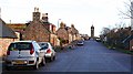
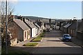
Main Street, Newmill
Newmill is one of numerous planned villages in north-eastern Scotland. They're are easily recognised by their wide straight streets like this one.
Image: © Anne Burgess
Taken: 19 Jan 2007
0.09 miles
8

Newmill Square
The houses in this north-western corner of the square are empty and boarded up. At least they provide a suitable spot for recycling facilities.
Image: © Anne Burgess
Taken: 19 Jan 2007
0.09 miles
9
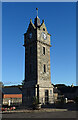
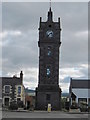
Newmill War Memorial
The clock tower was built in 1922-1923 as a memorial to the people of Newmill who died in the First World War. It was designed by local architect Francis D Robertson, who did not live to see it completed.
Image: © Anne Burgess
Taken: 8 Oct 2020
0.09 miles