IMAGES TAKEN NEAR TO
Grange, KEITH, AB55 6TP
Introduction
This page details the photographs taken nearby to AB55 6TP by members of the Geograph project.
The Geograph project started in 2005 with the aim of publishing, organising and preserving representative images for every square kilometre of Great Britain, Ireland and the Isle of Man.

There are currently over 7.5m images from over14,400 individuals and you can help contribute to the project by visiting https://www.geograph.org.uk
Image Map
Images are licensed for reuse under creativecommons.org/licenses/by-sa/2.0
Notes
- Clicking on the map will re-center to the selected point.
- The higher the marker number, the further away the image location is from the centre of the postcode.
Image Listing (3 Images Found)
Images are licensed for reuse under creativecommons.org/licenses/by-sa/2.0
Image
Details
Distance
1
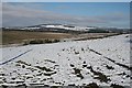
Bracobrae
Bracobrae Farm is among the trees at the foot of the ploughed field. In the distance is Lurg Hill.
Image: © Anne Burgess
Taken: 22 Feb 2010
0.16 miles
2

Bracobrae Farm
The farm of Bracobrae lies below the road along the slope of Sillyearn Hill. At the edge of the brown area, at left, is Northcott, and Bin View is above and to the right of Bracobrae Farm
Image: © Anne Burgess
Taken: 25 Feb 2009
0.17 miles
3

Bracobrae
The prominent farm on the left is by the Bracobrae road along the slope of Sillyearn Hill, but it is not named on the maps.
Image: © Anne Burgess
Taken: 25 Feb 2009
0.24 miles