IMAGES TAKEN NEAR TO
Grange, KEITH, AB55 6TJ
Introduction
This page details the photographs taken nearby to AB55 6TJ by members of the Geograph project.
The Geograph project started in 2005 with the aim of publishing, organising and preserving representative images for every square kilometre of Great Britain, Ireland and the Isle of Man.

There are currently over 7.5m images from over14,400 individuals and you can help contribute to the project by visiting https://www.geograph.org.uk
Image Map
Images are licensed for reuse under creativecommons.org/licenses/by-sa/2.0
Notes
- Clicking on the map will re-center to the selected point.
- The higher the marker number, the further away the image location is from the centre of the postcode.
Image Listing (6 Images Found)
Images are licensed for reuse under creativecommons.org/licenses/by-sa/2.0
Image
Details
Distance
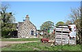
1
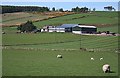
Roebank
The farm house and steading at Roebank.
Image: © Anne Burgess
Taken: 30 Apr 2007
0.02 miles
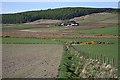
2
Clovenstones and Roebank
The nearer buildings are close to Roebank Farm. Clovenstones is the house further away and to the left.
Image: © Anne Burgess
Taken: 30 Apr 2007
0.08 miles
3
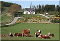
Whitehill
The house is one of a large number of new ones springing up all over the countryside. I think the cattle are beef cattle but I am unsure of the exact breed (Beef Shorthorn perhaps?)
Image: © Anne Burgess
Taken: 30 Apr 2007
0.16 miles
4
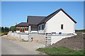
Whitehill
Another modern house nearing completion at Whitehill.
Image: © Anne Burgess
Taken: 30 Apr 2007
0.21 miles
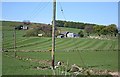
5
Sillyearn Mains
The Mains is on the slopes of Sillyearn Hill.
Image: © Anne Burgess
Taken: 30 Apr 2007
0.22 miles
6
Whitehill
The farm at Whitehill, showing the gable end of the old farm house.
Image: © Anne Burgess
Taken: 30 Apr 2007
0.25 miles