IMAGES TAKEN NEAR TO
Grange, KEITH, AB55 6TH
Introduction
This page details the photographs taken nearby to AB55 6TH by members of the Geograph project.
The Geograph project started in 2005 with the aim of publishing, organising and preserving representative images for every square kilometre of Great Britain, Ireland and the Isle of Man.

There are currently over 7.5m images from over14,400 individuals and you can help contribute to the project by visiting https://www.geograph.org.uk
Image Map
Images are licensed for reuse under creativecommons.org/licenses/by-sa/2.0
Notes
- Clicking on the map will re-center to the selected point.
- The higher the marker number, the further away the image location is from the centre of the postcode.
Image Listing (12 Images Found)
Images are licensed for reuse under creativecommons.org/licenses/by-sa/2.0
Image
Details
Distance
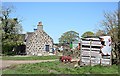
1
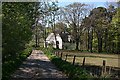
Whitehill
This is marked as a church on the 1:25,000 map, but has been converted into a house.
Image: © Anne Burgess
Taken: 30 Apr 2007
0.00 miles
2
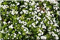
Woodruff (Galium odoratum)
As its Latin name suggests, this is one of the herbs formerly scattered among straw on floors to keep it sweet-smelling (or less evil-smelling, perhaps!).
Image: © Anne Burgess
Taken: 30 Apr 2007
0.02 miles
3
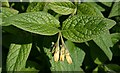
Comfrey
A common plant of damp soils. It was formerly used in medicine to aid healing of wounds. I think this is Tuberous Comfrey (Symphytum tuberosum) rather than Common Comfrey (S. officinale).
Image: © Anne Burgess
Taken: 30 Apr 2007
0.02 miles
4
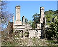
Whitehill House
The ruins now serve as a home for nesting Jackdaws.
Image: © Anne Burgess
Taken: 30 Apr 2007
0.06 miles
5
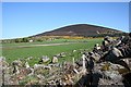
Upper Whitehill
The original farm house stands behind a cottage which has been or is being modernised. Knock Hill provides shelter on the north-east.
Image: © Anne Burgess
Taken: 30 Apr 2007
0.07 miles
6
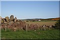
Upper Whitehill
Seen across the boulder dyke by the track towards Knock Hill.
Image: © Anne Burgess
Taken: 30 Apr 2007
0.08 miles
7
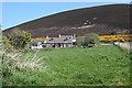
Whitehill and Knock Hill
This image shows how Whitehill nestles at the foot of Knock Hill. Note the size of the boulders scattered around the field, and imagine the work needed to clear the fields and build them into walls!
Image: © Anne Burgess
Taken: 30 Apr 2007
0.10 miles
8
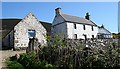
Upper Whitehill
This looks as if it has been the original farm house, though the steadings to the left have also been modernised and may be in use as housing.
Image: © Anne Burgess
Taken: 30 Apr 2007
0.11 miles
9
Whitehill
The farm at Whitehill, showing the gable end of the old farm house.
Image: © Anne Burgess
Taken: 30 Apr 2007
0.17 miles
10
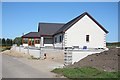
Whitehill
Another modern house nearing completion at Whitehill.
Image: © Anne Burgess
Taken: 30 Apr 2007
0.19 miles