IMAGES TAKEN NEAR TO
Grange, KEITH, AB55 6TB
Introduction
This page details the photographs taken nearby to AB55 6TB by members of the Geograph project.
The Geograph project started in 2005 with the aim of publishing, organising and preserving representative images for every square kilometre of Great Britain, Ireland and the Isle of Man.

There are currently over 7.5m images from over14,400 individuals and you can help contribute to the project by visiting https://www.geograph.org.uk
Image Map
Images are licensed for reuse under creativecommons.org/licenses/by-sa/2.0
Notes
- Clicking on the map will re-center to the selected point.
- The higher the marker number, the further away the image location is from the centre of the postcode.
Image Listing (3 Images Found)
Images are licensed for reuse under creativecommons.org/licenses/by-sa/2.0
Image
Details
Distance
1
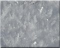
Snow Crystals
I wonder whether these snow crystals have been modified by slight thawing and refreezing, because they seem to be much larger than any snowflake I have ever seen.
Image: © Anne Burgess
Taken: 22 Feb 2010
0.03 miles
2
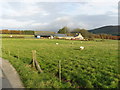
Westertown Farm
The farm is situated to the West of Knock Hill.
Image: © Christopher Gillan
Taken: 7 Nov 2006
0.11 miles
3
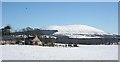
Westertown
The fuller name would be Westerton Edingight, to distinguish it from all the other Westertons on the map. Like everywhere else in Edingight, its situation is dominated by Knock Hill.
Image: © Anne Burgess
Taken: 22 Feb 2010
0.14 miles