IMAGES TAKEN NEAR TO
Grange, KEITH, AB55 6SX
Introduction
This page details the photographs taken nearby to AB55 6SX by members of the Geograph project.
The Geograph project started in 2005 with the aim of publishing, organising and preserving representative images for every square kilometre of Great Britain, Ireland and the Isle of Man.

There are currently over 7.5m images from over14,400 individuals and you can help contribute to the project by visiting https://www.geograph.org.uk
Image Map
Images are licensed for reuse under creativecommons.org/licenses/by-sa/2.0
Notes
- Clicking on the map will re-center to the selected point.
- The higher the marker number, the further away the image location is from the centre of the postcode.
Image Listing (4 Images Found)
Images are licensed for reuse under creativecommons.org/licenses/by-sa/2.0
Image
Details
Distance
1
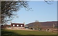
Fortry
The farm house faces south, and in the background is the north-western slope of Knock Hill.
Image: © Anne Burgess
Taken: 25 Feb 2009
0.01 miles
2

Fortry Farmhouse.
An attractive stone built farmhouse in traditional Scottish style. World cup venue perhaps??? Perhaps not; more likely to be Highland League!!
Image: © Christopher Gillan
Taken: 29 May 2006
0.02 miles
3
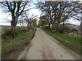
Minor road at Fortry Farm
Looking north-eastward.
Image: © Peter Wood
Taken: 24 Oct 2018
0.02 miles
4
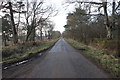
Long Straight Minor Road at Fortry Wood
Image: © Alan hodgson
Taken: 10 Feb 2016
0.17 miles