IMAGES TAKEN NEAR TO
Grange, KEITH, AB55 6SR
Introduction
This page details the photographs taken nearby to AB55 6SR by members of the Geograph project.
The Geograph project started in 2005 with the aim of publishing, organising and preserving representative images for every square kilometre of Great Britain, Ireland and the Isle of Man.

There are currently over 7.5m images from over14,400 individuals and you can help contribute to the project by visiting https://www.geograph.org.uk
Image Map
Images are licensed for reuse under creativecommons.org/licenses/by-sa/2.0
Notes
- Clicking on the map will re-center to the selected point.
- The higher the marker number, the further away the image location is from the centre of the postcode.
Image Listing (3 Images Found)
Images are licensed for reuse under creativecommons.org/licenses/by-sa/2.0
Image
Details
Distance
1
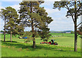
Making Hay
Or perhaps silage. The nearest tractor is collecting the cut grass into lines, and the other is scooping the lines of grass up and will transfer it to bogies to be taken to the farm yard.
Image: © Anne Burgess
Taken: 8 Jun 2023
0.08 miles
2
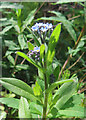
Field Forget-me-not (Myosotis arvense)
One of the commonest species of Forget-me-not, a weed of cultivation, it is characterised by its tiny concave flowers.
Image: © Anne Burgess
Taken: 8 Jun 2023
0.13 miles
3
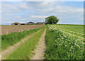
Lane to Bankhead
Formerly a through track, this now ends at the industrial premises at Limehillock.
Image: © Anne Burgess
Taken: 8 Jun 2023
0.24 miles