IMAGES TAKEN NEAR TO
Grange, KEITH, AB55 6SN
Introduction
This page details the photographs taken nearby to AB55 6SN by members of the Geograph project.
The Geograph project started in 2005 with the aim of publishing, organising and preserving representative images for every square kilometre of Great Britain, Ireland and the Isle of Man.

There are currently over 7.5m images from over14,400 individuals and you can help contribute to the project by visiting https://www.geograph.org.uk
Image Map
Images are licensed for reuse under creativecommons.org/licenses/by-sa/2.0
Notes
- Clicking on the map will re-center to the selected point.
- The higher the marker number, the further away the image location is from the centre of the postcode.
Image Listing (5 Images Found)
Images are licensed for reuse under creativecommons.org/licenses/by-sa/2.0
Image
Details
Distance
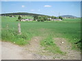
2
Remains of the Banff branch now just a dirt track
Image: © Peter Moore
Taken: 19 Jul 2016
0.20 miles
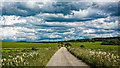
3
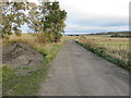
The track-bed of a dismantled railway line near Nethermills
Looking north-eastwards. Following the map trains from here would eventually arrive in Banff or Portsoy.
Image: © Peter Wood
Taken: 23 Oct 2018
0.20 miles
4
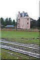
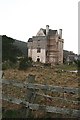
Issueburn
This curiously-named building is a completely new one, not a rebuilt castle. See also Image
Image: © Anne Burgess
Taken: 19 Mar 2007
0.21 miles
5
Issueburn
Issueburn is being built almost single-handed in the style of a traditional tower house, incorporating all the modifications made by successive generations over the last few hundred years. Though it still looks like a building site, it should be completed by the end of 2008.
Image: © Anne Burgess
Taken: 19 Mar 2007
0.21 miles