IMAGES TAKEN NEAR TO
Grange, KEITH, AB55 6SL
Introduction
This page details the photographs taken nearby to AB55 6SL by members of the Geograph project.
The Geograph project started in 2005 with the aim of publishing, organising and preserving representative images for every square kilometre of Great Britain, Ireland and the Isle of Man.

There are currently over 7.5m images from over14,400 individuals and you can help contribute to the project by visiting https://www.geograph.org.uk
Image Map
Images are licensed for reuse under creativecommons.org/licenses/by-sa/2.0
Notes
- Clicking on the map will re-center to the selected point.
- The higher the marker number, the further away the image location is from the centre of the postcode.
Image Listing (3 Images Found)
Images are licensed for reuse under creativecommons.org/licenses/by-sa/2.0
Image
Details
Distance
1
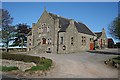
King Memorial Hall
This rather splendid and well-maintained hall serves the scattered community of Grange. This was taken in the morning to get the best light, which is why it looks deserted.
Image: © Anne Burgess
Taken: 30 Apr 2007
0.19 miles
2
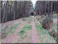
Forest track on Braco Hill
Looking northward.
Image: © Peter Wood
Taken: 23 Oct 2018
0.19 miles
3
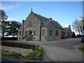
King Memorial Hall, Grange
A community hall situated on the north side of A95 Keith to Banff road.
Image: © Christopher Gillan
Taken: 29 May 2006
0.23 miles