IMAGES TAKEN NEAR TO
Grange, KEITH, AB55 6SH
Introduction
This page details the photographs taken nearby to AB55 6SH by members of the Geograph project.
The Geograph project started in 2005 with the aim of publishing, organising and preserving representative images for every square kilometre of Great Britain, Ireland and the Isle of Man.

There are currently over 7.5m images from over14,400 individuals and you can help contribute to the project by visiting https://www.geograph.org.uk
Image Map
Images are licensed for reuse under creativecommons.org/licenses/by-sa/2.0
Notes
- Clicking on the map will re-center to the selected point.
- The higher the marker number, the further away the image location is from the centre of the postcode.
Image Listing (8 Images Found)
Images are licensed for reuse under creativecommons.org/licenses/by-sa/2.0
Image
Details
Distance
1
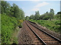
Grange railway station (site), Moray
Opened in 1856 on the Great North of Scotland Railway's line from Aberdeen to Keith, this station closed in 1968. The line was later singled.
View east towards Cairnie Junction and Aberdeen. The trees are a little closer to the track than when Image was taken from the same position some 20 years earlier.
Image: © Nigel Thompson
Taken: 26 May 2017
0.04 miles
2
Garrowood
The only ways to this house are a pedestrian crossing over the Aberdeen to Inverness railway line, or a footpath down from the forest track up the hill.
Image: © Anne Burgess
Taken: 19 Mar 2007
0.05 miles
3
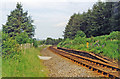
Grange station (remains), 1997
View eastward, towards Cairnie Junction, Huntly and Aberdeen: ex-GNSR Aberdeen - Huntly - Keith - Elgin - (Inverness) main line. This little station - on a single-track main line - was closed 6/5/68, when also the Coast Line from the (triangular) Cairnie Junction via Portsoy and Cullen to Keith was closed.
Image: © Ben Brooksbank
Taken: 2 Jul 1997
0.06 miles
4
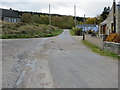
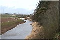
Minor roads at Varannes
Looking south-westward.
Image: © Peter Wood
Taken: 23 Oct 2018
0.07 miles
5
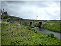
Bridge over River Isla near former Grange Station near Keith
Road bridge over River Isla.
Image: © Christopher Gillan
Taken: 29 May 2006
0.08 miles
6
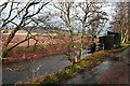
River Isla
In the distance is the bridge at Garrowood, where the former Grange station was situated.
Image: © Anne Burgess
Taken: 19 Mar 2007
0.10 miles
7
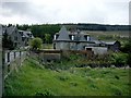
Craigisla near former Grange Station near Keith
These recently erected houses are close to the site of the now demolished Grange Station on the Aberdeen to Inverness railway. The house with the turret is Craigisla.
Image: © Christopher Gillan
Taken: 29 May 2006
0.10 miles
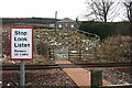
8
River Isla
I am not at all sure what the function of these huts is. There is a flight of steps leading right down to the river bank, and a wire slung across the river to the top of the pole on the far bank. A notice on the huts warns of unspecified danger.
Image: © Anne Burgess
Taken: 19 Mar 2007
0.13 miles