IMAGES TAKEN NEAR TO
Grange, KEITH, AB55 6SA
Introduction
This page details the photographs taken nearby to AB55 6SA by members of the Geograph project.
The Geograph project started in 2005 with the aim of publishing, organising and preserving representative images for every square kilometre of Great Britain, Ireland and the Isle of Man.

There are currently over 7.5m images from over14,400 individuals and you can help contribute to the project by visiting https://www.geograph.org.uk
Image Map
Images are licensed for reuse under creativecommons.org/licenses/by-sa/2.0
Notes
- Clicking on the map will re-center to the selected point.
- The higher the marker number, the further away the image location is from the centre of the postcode.
Image Listing (3 Images Found)
Images are licensed for reuse under creativecommons.org/licenses/by-sa/2.0
Image
Details
Distance
1
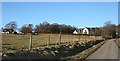
New Houses in Grange
According to a notice at its gate, the large white house is named The Beeches, but I failed to notice the name of the house on the left. They both enjoy a fine view, and are sheltered by the trees to the north.
Image: © Anne Burgess
Taken: 25 Feb 2009
0.01 miles
2
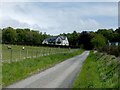
Bear Hill, Davoch of Grange.
New house on an elevated site named Bear Hill.
Image: © Christopher Gillan
Taken: 29 May 2006
0.12 miles
3
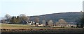
Muiryfold
Another farm with extensive outbuildings. Little Balloch is in the background.
Image: © Anne Burgess
Taken: 25 Feb 2009
0.17 miles