IMAGES TAKEN NEAR TO
KEITH, AB55 6RU
Introduction
This page details the photographs taken nearby to AB55 6RU by members of the Geograph project.
The Geograph project started in 2005 with the aim of publishing, organising and preserving representative images for every square kilometre of Great Britain, Ireland and the Isle of Man.

There are currently over 7.5m images from over14,400 individuals and you can help contribute to the project by visiting https://www.geograph.org.uk
Image Map
Images are licensed for reuse under creativecommons.org/licenses/by-sa/2.0
Notes
- Clicking on the map will re-center to the selected point.
- The higher the marker number, the further away the image location is from the centre of the postcode.
Image Listing (16 Images Found)
Images are licensed for reuse under creativecommons.org/licenses/by-sa/2.0
Image
Details
Distance
1
Former Tollhouse by the A95, Fife Keith
Tollhouse Bridgend by the A95, in parish of Fife Keith (Moray District), Toll Cottage, Fife Keith.
Surveyed
Milestone Society National ID: MO.FIF
Image: © Milestone Society
Taken: Unknown
0.00 miles
3
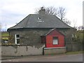
Bridgend, Keith
The house was formerly a toll house on what is now the A96 Keith/Craigellachie main road. The original building is the multi-sided edifice nearest the road. It has been extended over the years.
Image: © Christopher Gillan
Taken: 15 Apr 2006
0.08 miles
4
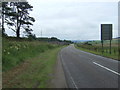
A95 heading south west
Towards Charlestown of Aberlour.
Image: © JThomas
Taken: 20 Jul 2014
0.10 miles
5
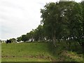
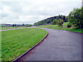
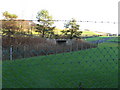
Farmland, Bridgend
Cattle grazing amongst birch trees.
Image: © Richard Webb
Taken: 9 Aug 2007
0.10 miles
6
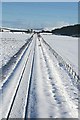
Railway near Keith
Looking towards the east along the Inverness to Aberdeen railway line. Beside the line, after the next overbridge are some of the bonded warehouses where whisky is matured. The hill in the distance is Knock Hill.
Image: © Anne Burgess
Taken: 11 Feb 2009
0.13 miles
7
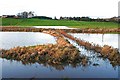
After the Downpour
The heavy rain on Sunday night has left the fields under water. The railway, which runs across the middle of this view, was not submerged here, but services were disrupted somewhere along the line today. The farm at top left is Burnside.
Image: © Anne Burgess
Taken: 2 Nov 2009
0.13 miles
8
Road Bridge on A96 at Keith
Bridge which carries the A96 Aberdeen to Inverness trunk road over the single track railway between the same two Cities. 1 of over 30 of Chivas Bonded Warehouses is in the background. You will notice a McPherson's of Aberlour whisky tanker on the bridge, bound almost certainly, to collect some Chivas Regal!
Image: © Christopher Gillan
Taken: 4 Jan 2006
0.15 miles
9
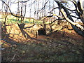
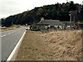
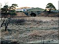
Bridge over disused Railway near Keith
Bridge over disused Highland Railway line near Keith.
Image: © Christopher Gillan
Taken: 1 Dec 2006
0.17 miles
10
Bridge over disused Railway near Keith
This Bridge is just outside the perimeter fence at Chivas Bond,Keith.
Image: © Christopher Gillan
Taken: 1 Dec 2006
0.18 miles