IMAGES TAKEN NEAR TO
KEITH, AB55 6RS
Introduction
This page details the photographs taken nearby to AB55 6RS by members of the Geograph project.
The Geograph project started in 2005 with the aim of publishing, organising and preserving representative images for every square kilometre of Great Britain, Ireland and the Isle of Man.

There are currently over 7.5m images from over14,400 individuals and you can help contribute to the project by visiting https://www.geograph.org.uk
Image Map
Images are licensed for reuse under creativecommons.org/licenses/by-sa/2.0
Notes
- Clicking on the map will re-center to the selected point.
- The higher the marker number, the further away the image location is from the centre of the postcode.
Image Listing (14 Images Found)
Images are licensed for reuse under creativecommons.org/licenses/by-sa/2.0
Image
Details
Distance
1
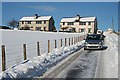
Loanbank Cottages
Two blocks of houses whose design screams 'council house'. They are completely unlike either the traditional buildings which precede them, or the more recent style of house.
Image: © Anne Burgess
Taken: 11 Feb 2009
0.01 miles
2
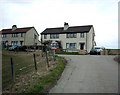
Loanbank Cottages, near Keith
Although described as cottages these houses are rather more substantial than that!
Image: © Christopher Gillan
Taken: 15 Apr 2006
0.06 miles
3
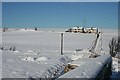
Near Allanbuie
The hump-backed railway overbridge offers an excellent viewpoint over the surrounding countryside. The prominent houses are Loanbank Cottages, andf Mains of Allanbuie is to the left.
Image: © Anne Burgess
Taken: 11 Feb 2009
0.08 miles
4
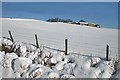
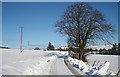
Burnside Farm
Snow-covered farmland just outside Keith.
Image: © Anne Burgess
Taken: 11 Feb 2009
0.11 miles
5

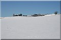
Burnside Farm
Looking up from the railway overbridge to the farm buildings at Burnside.
Image: © Anne Burgess
Taken: 11 Feb 2009
0.11 miles
6

Burnside of Allanbuie
These days the farm is known as plain Burnside, but it's not the only Burnside in the vicinity. The 1868 Ordnance Survey six-inch-t-the-mile map gives it the full name.
Image: © Anne Burgess
Taken: 6 Jul 2012
0.12 miles
7
Burnside Farm
A substantial farm just outside Keith.
Image: © Anne Burgess
Taken: 11 Feb 2009
0.12 miles
8
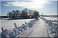
Near Crooksmill
The back road from Crooksmill to Burnside under a blanket of snow.
Image: © Anne Burgess
Taken: 11 Feb 2009
0.17 miles
9
Mains of Allanbuie
The farm buildings are partly hidden by the lie of the land.
Image: © Anne Burgess
Taken: 11 Feb 2009
0.18 miles
