IMAGES TAKEN NEAR TO
KEITH, AB55 6RN
Introduction
This page details the photographs taken nearby to AB55 6RN by members of the Geograph project.
The Geograph project started in 2005 with the aim of publishing, organising and preserving representative images for every square kilometre of Great Britain, Ireland and the Isle of Man.

There are currently over 7.5m images from over14,400 individuals and you can help contribute to the project by visiting https://www.geograph.org.uk
Image Map
Images are licensed for reuse under creativecommons.org/licenses/by-sa/2.0
Notes
- Clicking on the map will re-center to the selected point.
- The higher the marker number, the further away the image location is from the centre of the postcode.
Image Listing (8 Images Found)
Images are licensed for reuse under creativecommons.org/licenses/by-sa/2.0
Image
Details
Distance
1
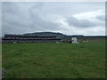
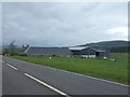
Newton of Forgie
A large farm to the north of the A96, from the side of which this shot was taken.
Image: © Anne Burgess
Taken: 5 Jan 2009
0.03 miles
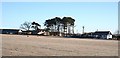
5
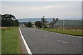
Nearing the turn off on the left for Newton of Forgie.
Image: © Des Colhoun
Taken: 10 Sep 2006
0.13 miles