IMAGES TAKEN NEAR TO
KEITH, AB55 6RD
Introduction
This page details the photographs taken nearby to AB55 6RD by members of the Geograph project.
The Geograph project started in 2005 with the aim of publishing, organising and preserving representative images for every square kilometre of Great Britain, Ireland and the Isle of Man.

There are currently over 7.5m images from over14,400 individuals and you can help contribute to the project by visiting https://www.geograph.org.uk
Image Map
Images are licensed for reuse under creativecommons.org/licenses/by-sa/2.0
Notes
- Clicking on the map will re-center to the selected point.
- The higher the marker number, the further away the image location is from the centre of the postcode.
Image Listing (12 Images Found)
Images are licensed for reuse under creativecommons.org/licenses/by-sa/2.0
Image
Details
Distance
1
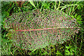
Natural Lace
I was intrigued to see that something has been transforming leaves of Broad-leaved Dock (Rumex obtusifolius) into a delicate lacy pattern.
Image: © Anne Burgess
Taken: 17 Jul 2020
0.08 miles
2
Raefin
A small patch of spruce has escaped felling here. In the foreground there are Scots Pine saplings.
Image: © Anne Burgess
Taken: 8 Dec 2006
0.09 miles
3
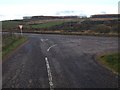
Looking towards Corsekell Moss
On the right is the access road to Raefin.
Image: © Anne Burgess
Taken: 17 Jul 2020
0.12 miles
4
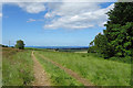
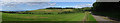
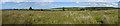
Field with a View
From the top of the Braes of Enzie there is a fine view towards the Moray Firth.
Image: © Anne Burgess
Taken: 17 Jul 2020
0.13 miles
5
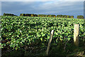
Brassica Crop
I'm not suffiently knowledgeable to be able to tell what this crop is, other than it's not oilseed rape. Maybe neeps?
Image: © Anne Burgess
Taken: 9 Nov 2021
0.18 miles
6
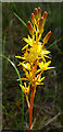
Bog Asphodel (Narthecium ossifragum)
Having resigned myself to not being able to go to the places where I would usually expect to find Bog Asphodel this year, thanks to Covid-19, I was delighted to come across several patches of it in the ditch here.
Image: © Anne Burgess
Taken: 17 Jul 2020
0.19 miles
7
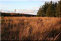
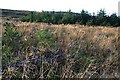
Raefin
The moorland just west of Raefin Farm is mapped as forest, but the trees have been felled so it looks much more open.
Image: © Anne Burgess
Taken: 8 Dec 2006
0.20 miles
8
Above Raefin
You can just about make out the roofs of Raefin at right of centre, and the strip of forestry, both of which are partly hidden from here by the lie of the land.
Image: © Anne Burgess
Taken: 17 Jul 2020
0.21 miles
9
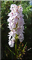
Heath Spotted Orchid (Dactylorhiza maculata)
Most of the specimens of this plant are beginning to wither, but this one is in perfect condition.
Image: © Anne Burgess
Taken: 17 Jul 2020
0.22 miles