IMAGES TAKEN NEAR TO
KEITH, AB55 6QS
Introduction
This page details the photographs taken nearby to AB55 6QS by members of the Geograph project.
The Geograph project started in 2005 with the aim of publishing, organising and preserving representative images for every square kilometre of Great Britain, Ireland and the Isle of Man.

There are currently over 7.5m images from over14,400 individuals and you can help contribute to the project by visiting https://www.geograph.org.uk
Image Map
Images are licensed for reuse under creativecommons.org/licenses/by-sa/2.0
Notes
- Clicking on the map will re-center to the selected point.
- The higher the marker number, the further away the image location is from the centre of the postcode.
Image Listing (4 Images Found)
Images are licensed for reuse under creativecommons.org/licenses/by-sa/2.0
Image
Details
Distance
1
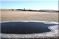
Little Forgie
The farm itself is a bit distant, beyond a frozen ephemeral pond and the cutting of the former railway from Keith to Buckie, which is hidden by the lie of the land here.
Image: © Anne Burgess
Taken: 5 Jan 2009
0.01 miles
3
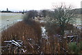
Disused railway near Keith
Looking SE from position
Image: © Iain Macaulay
Taken: 29 Nov 2005
0.18 miles