IMAGES TAKEN NEAR TO
KEITH, AB55 6QQ
Introduction
This page details the photographs taken nearby to AB55 6QQ by members of the Geograph project.
The Geograph project started in 2005 with the aim of publishing, organising and preserving representative images for every square kilometre of Great Britain, Ireland and the Isle of Man.

There are currently over 7.5m images from over14,400 individuals and you can help contribute to the project by visiting https://www.geograph.org.uk
Image Map
Images are licensed for reuse under creativecommons.org/licenses/by-sa/2.0
Notes
- Clicking on the map will re-center to the selected point.
- The higher the marker number, the further away the image location is from the centre of the postcode.
Image Listing (13 Images Found)
Images are licensed for reuse under creativecommons.org/licenses/by-sa/2.0
Image
Details
Distance
1
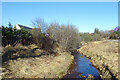
Burn of Crooksmill
Looking upstream from the bridge at Crooksmill.
Image: © Anne Burgess
Taken: 26 Feb 2021
0.02 miles
2
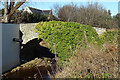
Crooksmill Bridge
This early 19th century bridge over the Burn of Crooksmill is a Category C Listed building. It's a pity that the wall on the far bank hides so much of the masonry on that side.
Image: © Anne Burgess
Taken: 26 Feb 2021
0.05 miles
3
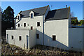
Crooksmill House
Crooks Mill was designated a Category B Listed Building in 1988. The citation says, "1895, incorporating earlier fabric. Double gabled meal mill, harled and harl pointed rubble with timber and corrugated-iron extension at West. Skeletal wheel at South gable, kiln with louvred ridge cupola at North. Varied fenestration and glazing; slate roofs. Interior: all machinery present and working, now powered
by electricity". Since then it has been restored and offers bed and breakfast.
Image: © Anne Burgess
Taken: 26 Feb 2021
0.06 miles
4
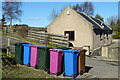
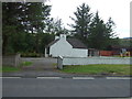
Wheelie Bins
Another phalanx of Moray Council's garish wheelie bins cluttering up the countryside.
Image: © Anne Burgess
Taken: 26 Feb 2021
0.06 miles
5
Crooksmill
The mill itself is hidden in this view by the new houses which have been built round it.
Image: © Anne Burgess
Taken: 11 Feb 2009
0.10 miles
6
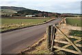
Whitecrook
Looking along the B9017 towards Whitecrook Farm. The hill in the distance is the Hill of Muldearie in Image
Image: © Anne Burgess
Taken: 15 Jan 2007
0.12 miles
7
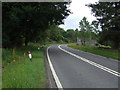
A bend in the A96
Heading south east towards Keith.
Image: © JThomas
Taken: 20 Jul 2014
0.12 miles
9
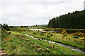
Crooksmill Pond
The Mill pond and Crooksmill Burn north of Keith.
Image: © Andrew Wood
Taken: 4 Jun 2009
0.19 miles
10
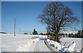
Near Crooksmill
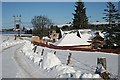
The back road from Crooksmill to Burnside under a blanket of snow.
Image: © Anne Burgess
Taken: 11 Feb 2009
0.19 miles